You are here: Home > Network List > XE05 - Sierra Nevada EarthScope Project- EarthScope Flex Array Stations List
> Station SNPG7 SNPG7 > Earthquake Result Viewer
SNPG7 SNPG7 - Earthquake Result Viewer
| Earthquake location: |
Chile-Argentina Border Region |
| Earthquake latitude/longitude: |
-24.4/-67.0 |
| Earthquake time(UTC): |
2006/08/25 (237) 00:44:46 GMT |
| Earthquake Depth: |
184 km |
| Earthquake Magnitude: |
5.9 MB, 6.6 MW, 6.6 MW |
| Earthquake Catalog/Contributor: |
WHDF/NEIC |
|
| Network: |
XE Sierra Nevada EarthScope Project- EarthScope Flex Array |
| Station: |
SNPG7 SNPG7 |
| Lat/Lon: |
40.11 N/121.17 W |
| Elevation: |
1591 m |
|
| Distance: |
81.6 deg |
| Az: |
321.073 deg |
| Baz: |
131.677 deg |
| Ray Param: |
0.047014866 |
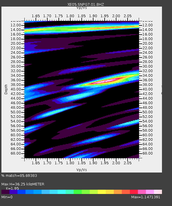
| Estimated Moho Depth: |
36.25 km |
| Estimated Crust Vp/Vs: |
1.95 |
| Assumed Crust Vp: |
6.566 km/s |
| Estimated Crust Vs: |
3.367 km/s |
| Estimated Crust Poisson's Ratio: |
0.32 |
|
| Radial Match: |
85.69383 % |
| Radial Bump: |
400 |
| Transverse Match: |
81.438576 % |
| Transverse Bump: |
400 |
| SOD ConfigId: |
268666 |
| Insert Time: |
2010-03-09 19:37:38.527 +0000 |
| GWidth: |
2.5 |
| Max Bumps: |
400 |
| Tol: |
0.001 |
|

Signal To Noise
| Channel | StoN | STA | LTA |
| XE:SNPG7:01:BHZ:20060825T00:56:12.349006Z | 20.294737 | 1.6835997E-6 | 8.295745E-8 |
| XE:SNPG7:01:BHN:20060825T00:56:12.349006Z | 2.3344936 | 3.0355915E-7 | 1.3003212E-7 |
| XE:SNPG7:01:BHE:20060825T00:56:12.349006Z | 2.5412934 | 3.809415E-7 | 1.4990063E-7 |
| Arrivals |
| Ps | 5.4 SECOND |
| PpPs | 16 SECOND |
| PsPs/PpSs | 21 SECOND |


