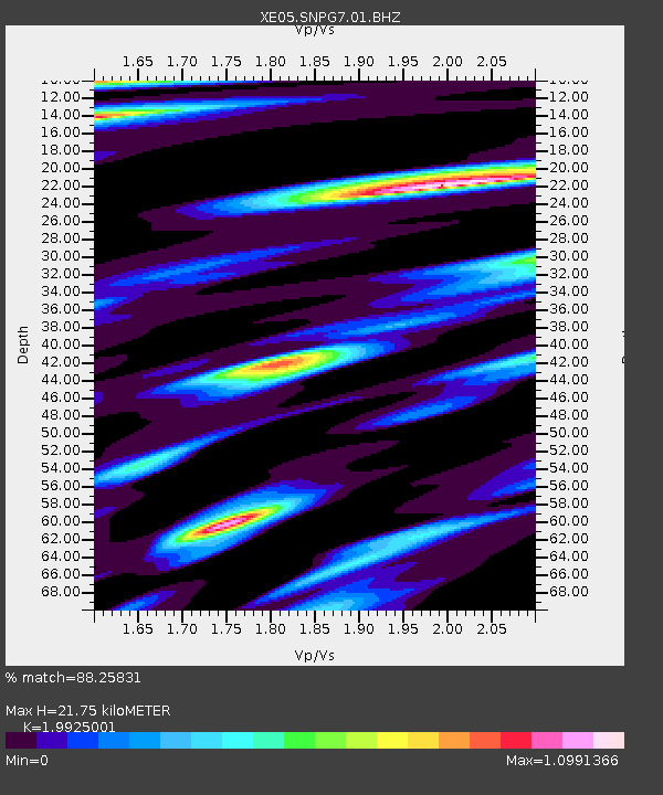
SNPG7 SNPG7 - Earthquake Result Viewer

Earthquake location: Kuril Islands
Earthquake latitude/longitude: 46.5/153.2
Earthquake time(UTC): 2006/10/01 (274) 09:06:02 GMT
Earthquake Depth: 19 km
Earthquake Magnitude: 6.1 MB, 6.4 MS, 6.6 MW, 6.5 MW
Earthquake Catalog/Contributor: WHDF/NEIC
Network: XE Sierra Nevada EarthScope Project- EarthScope Flex Array
Station: SNPG7 SNPG7
Lat/Lon: 40.11 N/121.17 W
Elevation: 1591 m
Distance: 59.7 deg
Az: 62.334 deg
Baz: 307.046 deg
Ray Param: 0.061996367
Estimated Moho Depth: 21.75 km
Estimated Crust Vp/Vs: 1.99
Assumed Crust Vp: 6.566 km/s
Estimated Crust Vs: 3.295 km/s
Estimated Crust Poisson's Ratio: 0.33
Radial Match: 88.25831 %
Radial Bump: 352
Transverse Match: 84.66291 %
Transverse Bump: 364
SOD ConfigId: 268666
Insert Time: 2010-03-09 19:37:42.499 +0000
GWidth: 2.5
Max Bumps: 400
Tol: 0.001

Signal To Noise

ChannelStoNSTALTA
XE:SNPG7:01:BHZ:20061001T09:15:34.46502Z7.57726537.0972806E-79.366546E-8
XE:SNPG7:01:BHN:20061001T09:15:34.46502Z1.81639973.3832742E-71.8626265E-7
XE:SNPG7:01:BHE:20061001T09:15:34.46502Z2.1352882.933165E-71.3736624E-7
Arrivals
Ps3.4 SECOND
PpPs9.5 SECOND
PsPs/PpSs13 SECOND