You are here: Home > Network List > II - Global Seismograph Network (GSN - IRIS/IDA) Stations List
> Station SUR Sutherland, South Africa > Earthquake Result Viewer
SUR Sutherland, South Africa - Earthquake Result Viewer
| Earthquake location: |
Java, Indonesia |
| Earthquake latitude/longitude: |
-7.8/107.3 |
| Earthquake time(UTC): |
2009/09/02 (245) 07:55:01 GMT |
| Earthquake Depth: |
46 km |
| Earthquake Magnitude: |
6.8 MB, 7.0 MS, 7.0 MW, 7.0 MW |
| Earthquake Catalog/Contributor: |
WHDF/NEIC |
|
| Network: |
II Global Seismograph Network (GSN - IRIS/IDA) |
| Station: |
SUR Sutherland, South Africa |
| Lat/Lon: |
32.38 S/20.81 E |
| Elevation: |
1770 m |
|
| Distance: |
82.9 deg |
| Az: |
238.323 deg |
| Baz: |
94.707 deg |
| Ray Param: |
0.046470184 |
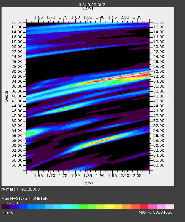
| Estimated Moho Depth: |
31.75 km |
| Estimated Crust Vp/Vs: |
2.00 |
| Assumed Crust Vp: |
6.51 km/s |
| Estimated Crust Vs: |
3.255 km/s |
| Estimated Crust Poisson's Ratio: |
0.33 |
|
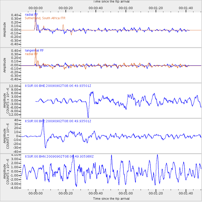
| Radial Match: |
90.26393 % |
| Radial Bump: |
336 |
| Transverse Match: |
81.77484 % |
| Transverse Bump: |
400 |
| SOD ConfigId: |
1 |
| Insert Time: |
2010-02-19 00:04:43.923 +0000 |
| GWidth: |
2.5 |
| Max Bumps: |
400 |
| Tol: |
0.001 |
|
Signal To Noise
| Channel | StoN | STA | LTA |
| II:SUR:00:BHZ:20090902T08:06:49.93501Z | 13.204046 | 1.0759145E-5 | 8.14837E-7 |
| II:SUR:00:BHN:20090902T08:06:49.935986Z | 1.2154826 | 9.700333E-7 | 7.980643E-7 |
| II:SUR:00:BHE:20090902T08:06:49.93501Z | 3.1019466 | 3.5278026E-6 | 1.1372867E-6 |
| Arrivals |
| Ps | 5.0 SECOND |
| PpPs | 14 SECOND |
| PsPs/PpSs | 19 SECOND |


