You are here: Home > Network List > SC - New Mexico Tech Seismic Network Stations List
> Station GDL2 Guadalupe Mountains, New Mexico > Earthquake Result Viewer
GDL2 Guadalupe Mountains, New Mexico - Earthquake Result Viewer
| Earthquake location: |
Rat Islands, Aleutian Islands |
| Earthquake latitude/longitude: |
51.1/178.6 |
| Earthquake time(UTC): |
2022/05/18 (138) 06:27:56 GMT |
| Earthquake Depth: |
36 km |
| Earthquake Magnitude: |
5.6 Mb |
| Earthquake Catalog/Contributor: |
NEIC PDE/at |
|
| Network: |
SC New Mexico Tech Seismic Network |
| Station: |
GDL2 Guadalupe Mountains, New Mexico |
| Lat/Lon: |
32.20 N/104.36 W |
| Elevation: |
1211 m |
|
| Distance: |
57.9 deg |
| Az: |
77.253 deg |
| Baz: |
313.506 deg |
| Ray Param: |
0.06313174 |
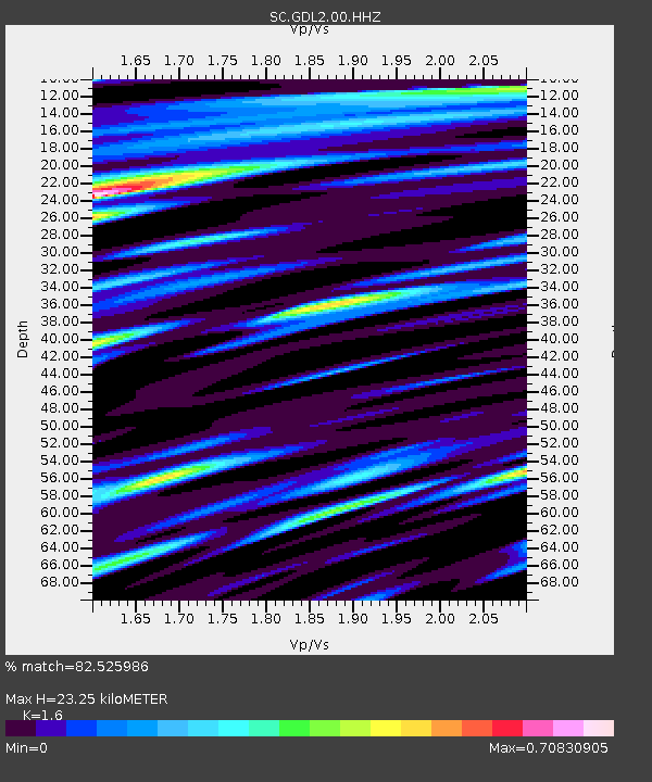
| Estimated Moho Depth: |
23.25 km |
| Estimated Crust Vp/Vs: |
1.60 |
| Assumed Crust Vp: |
6.232 km/s |
| Estimated Crust Vs: |
3.895 km/s |
| Estimated Crust Poisson's Ratio: |
0.18 |
|
| Radial Match: |
82.525986 % |
| Radial Bump: |
400 |
| Transverse Match: |
67.47449 % |
| Transverse Bump: |
400 |
| SOD ConfigId: |
27527651 |
| Insert Time: |
2022-06-01 21:29:28.053 +0000 |
| GWidth: |
2.5 |
| Max Bumps: |
400 |
| Tol: |
0.001 |
|

Signal To Noise
| Channel | StoN | STA | LTA |
| SC:GDL2:00:HHZ:20220518T06:37:13.715027Z | 8.205927 | 3.106359E-8 | 3.7855066E-9 |
| SC:GDL2:00:HHN:20220518T06:37:13.715027Z | 4.658024 | 1.2950832E-8 | 2.7803277E-9 |
| SC:GDL2:00:HHE:20220518T06:37:13.715027Z | 4.197251 | 1.0074139E-8 | 2.4001756E-9 |
| Arrivals |
| Ps | 2.4 SECOND |
| PpPs | 9.2 SECOND |
| PsPs/PpSs | 12 SECOND |


