You are here: Home > Network List > US - United States National Seismic Network Stations List
> Station HAWA Hanford, Washington, USA > Earthquake Result Viewer
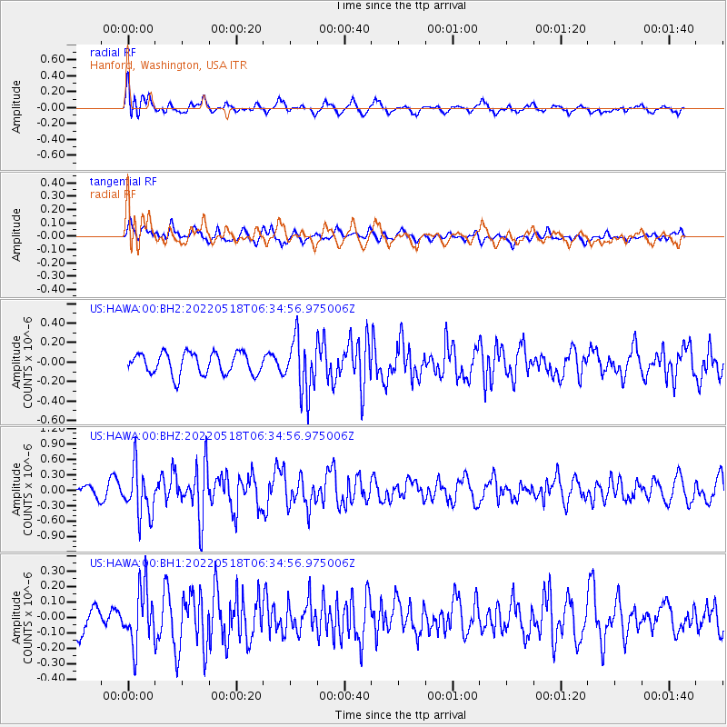
HAWA Hanford, Washington, USA - Earthquake Result Viewer
*The percent match for this event was below the threshold and hence no stack was calculated.
| Earthquake location: |
Rat Islands, Aleutian Islands |
| Earthquake latitude/longitude: |
51.1/178.6 |
| Earthquake time(UTC): |
2022/05/18 (138) 06:27:56 GMT |
| Earthquake Depth: |
36 km |
| Earthquake Magnitude: |
5.6 Mb |
| Earthquake Catalog/Contributor: |
NEIC PDE/at |
|
| Network: |
US United States National Seismic Network |
| Station: |
HAWA Hanford, Washington, USA |
| Lat/Lon: |
46.39 N/119.53 W |
| Elevation: |
364 m |
|
| Distance: |
40.0 deg |
| Az: |
71.703 deg |
| Baz: |
300.138 deg |
| Ray Param: |
$rayparam |
*The percent match for this event was below the threshold and hence was not used in the summary stack. |
|
| Radial Match: |
61.931644 % |
| Radial Bump: |
400 |
| Transverse Match: |
54.34898 % |
| Transverse Bump: |
400 |
| SOD ConfigId: |
27527651 |
| Insert Time: |
2022-06-01 21:32:50.750 +0000 |
| GWidth: |
2.5 |
| Max Bumps: |
400 |
| Tol: |
0.001 |
|
Signal To Noise
| Channel | StoN | STA | LTA |
| US:HAWA:00:BHZ:20220518T06:34:56.975006Z | 4.5893517 | 4.6839662E-7 | 1.0206161E-7 |
| US:HAWA:00:BH1:20220518T06:34:56.975006Z | 2.5475771 | 1.8450692E-7 | 7.242447E-8 |
| US:HAWA:00:BH2:20220518T06:34:56.975006Z | 2.538731 | 2.7903332E-7 | 1.09910545E-7 |
| Arrivals |
| Ps | |
| PpPs | |
| PsPs/PpSs | |


