You are here: Home > Network List > UW - Pacific Northwest Regional Seismic Network Stations List
> Station UMAT Pilot Rock, OR, USA > Earthquake Result Viewer
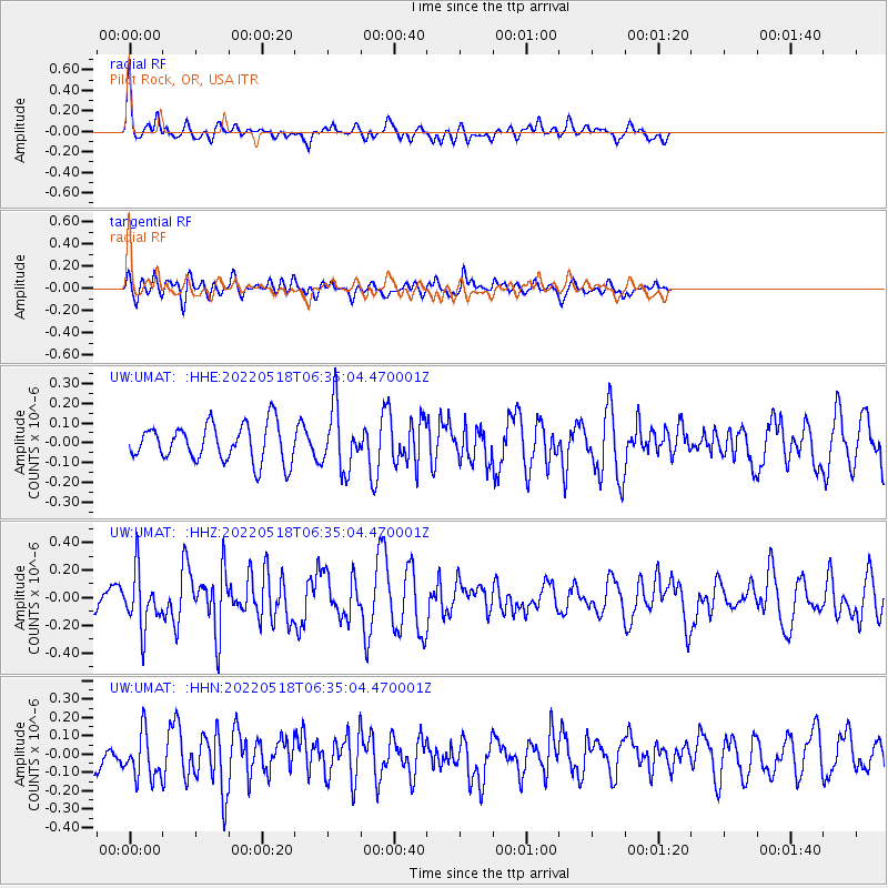
UMAT Pilot Rock, OR, USA - Earthquake Result Viewer
*The percent match for this event was below the threshold and hence no stack was calculated.
| Earthquake location: |
Rat Islands, Aleutian Islands |
| Earthquake latitude/longitude: |
51.1/178.6 |
| Earthquake time(UTC): |
2022/05/18 (138) 06:27:56 GMT |
| Earthquake Depth: |
36 km |
| Earthquake Magnitude: |
5.6 Mb |
| Earthquake Catalog/Contributor: |
NEIC PDE/at |
|
| Network: |
UW Pacific Northwest Regional Seismic Network |
| Station: |
UMAT Pilot Rock, OR, USA |
| Lat/Lon: |
45.29 N/118.96 W |
| Elevation: |
1318 m |
|
| Distance: |
40.9 deg |
| Az: |
72.846 deg |
| Baz: |
301.418 deg |
| Ray Param: |
$rayparam |
*The percent match for this event was below the threshold and hence was not used in the summary stack. |
|
| Radial Match: |
77.3889 % |
| Radial Bump: |
400 |
| Transverse Match: |
60.743855 % |
| Transverse Bump: |
400 |
| SOD ConfigId: |
27527651 |
| Insert Time: |
2022-06-01 21:35:30.446 +0000 |
| GWidth: |
2.5 |
| Max Bumps: |
400 |
| Tol: |
0.001 |
|
Signal To Noise
| Channel | StoN | STA | LTA |
| UW:UMAT: :HHZ:20220518T06:35:04.470001Z | 2.309929 | 2.0228212E-7 | 8.757071E-8 |
| UW:UMAT: :HHN:20220518T06:35:04.470001Z | 3.1206734 | 1.282809E-7 | 4.11068E-8 |
| UW:UMAT: :HHE:20220518T06:35:04.470001Z | 1.6925567 | 1.5759858E-7 | 9.311273E-8 |
| Arrivals |
| Ps | |
| PpPs | |
| PsPs/PpSs | |


