You are here: Home > Network List > TX - Texas Seismological Network Stations List
> Station WTFS Witchita Falls > Earthquake Result Viewer
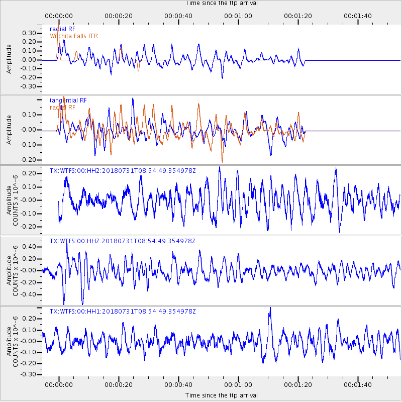
WTFS Witchita Falls - Earthquake Result Viewer
*The percent match for this event was below the threshold and hence no stack was calculated.
| Earthquake location: |
Near East Coast Of Honshu, Japan |
| Earthquake latitude/longitude: |
37.2/141.2 |
| Earthquake time(UTC): |
2018/07/31 (212) 08:42:20 GMT |
| Earthquake Depth: |
10 km |
| Earthquake Magnitude: |
5.4 Mww |
| Earthquake Catalog/Contributor: |
NEIC PDE/us |
|
| Network: |
TX Texas Seismological Network |
| Station: |
WTFS Witchita Falls |
| Lat/Lon: |
33.77 N/98.46 W |
| Elevation: |
277 m |
|
| Distance: |
90.2 deg |
| Az: |
45.949 deg |
| Baz: |
316.438 deg |
| Ray Param: |
$rayparam |
*The percent match for this event was below the threshold and hence was not used in the summary stack. |
|
| Radial Match: |
56.23033 % |
| Radial Bump: |
339 |
| Transverse Match: |
60.55894 % |
| Transverse Bump: |
400 |
| SOD ConfigId: |
2778632 |
| Insert Time: |
2018-08-14 08:54:28.241 +0000 |
| GWidth: |
2.5 |
| Max Bumps: |
400 |
| Tol: |
0.001 |
|
Signal To Noise
| Channel | StoN | STA | LTA |
| TX:WTFS:00:HHZ:20180731T08:54:49.354978Z | 3.5272582 | 2.2342638E-7 | 6.3342796E-8 |
| TX:WTFS:00:HH1:20180731T08:54:49.354978Z | 1.15274 | 7.359455E-8 | 6.3843146E-8 |
| TX:WTFS:00:HH2:20180731T08:54:49.354978Z | 0.8850494 | 5.772241E-8 | 6.5219425E-8 |
| Arrivals |
| Ps | |
| PpPs | |
| PsPs/PpSs | |


