You are here: Home > Network List > AU - Australian Seismological Centre Stations List
> Station BMEBF Broome Borefield > Earthquake Result Viewer
BMEBF Broome Borefield - Earthquake Result Viewer
| Earthquake location: |
Tonga Islands |
| Earthquake latitude/longitude: |
-16.1/-173.6 |
| Earthquake time(UTC): |
2022/05/19 (139) 09:23:52 GMT |
| Earthquake Depth: |
150 km |
| Earthquake Magnitude: |
6.0 Mi |
| Earthquake Catalog/Contributor: |
NEIC PDE/pt |
|
| Network: |
AU Australian Seismological Centre |
| Station: |
BMEBF Broome Borefield |
| Lat/Lon: |
17.87 S/122.87 E |
| Elevation: |
45 m |
|
| Distance: |
60.5 deg |
| Az: |
258.327 deg |
| Baz: |
98.703 deg |
| Ray Param: |
0.06103388 |
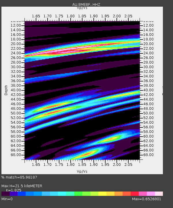
| Estimated Moho Depth: |
21.5 km |
| Estimated Crust Vp/Vs: |
1.83 |
| Assumed Crust Vp: |
6.159 km/s |
| Estimated Crust Vs: |
3.375 km/s |
| Estimated Crust Poisson's Ratio: |
0.29 |
|
| Radial Match: |
85.96187 % |
| Radial Bump: |
232 |
| Transverse Match: |
85.97349 % |
| Transverse Bump: |
242 |
| SOD ConfigId: |
27527651 |
| Insert Time: |
2022-06-02 09:28:13.468 +0000 |
| GWidth: |
2.5 |
| Max Bumps: |
400 |
| Tol: |
0.001 |
|

Signal To Noise
| Channel | StoN | STA | LTA |
| AU:BMEBF: :HHZ:20220519T09:33:15.494995Z | 0.73334956 | 2.160155E-6 | 2.9456007E-6 |
| $trig.getChannelId() | $trig.getValue() | $trig.getSTA() | $trig.getLTA() |
| AU:BMEBF: :HHE:20220519T09:33:15.494995Z | 0.97876006 | 2.2660686E-6 | 2.3152443E-6 |
| Arrivals |
| Ps | 3.0 SECOND |
| PpPs | 9.5 SECOND |
| PsPs/PpSs | 12 SECOND |


