You are here: Home > Network List > AV - Alaska Volcano Observatory Stations List
> Station GAEA East, Gareloi Volcano, Alaska > Earthquake Result Viewer
GAEA East, Gareloi Volcano, Alaska - Earthquake Result Viewer
| Earthquake location: |
Tonga Islands |
| Earthquake latitude/longitude: |
-16.1/-173.6 |
| Earthquake time(UTC): |
2022/05/19 (139) 09:23:52 GMT |
| Earthquake Depth: |
150 km |
| Earthquake Magnitude: |
6.0 Mi |
| Earthquake Catalog/Contributor: |
NEIC PDE/pt |
|
| Network: |
AV Alaska Volcano Observatory |
| Station: |
GAEA East, Gareloi Volcano, Alaska |
| Lat/Lon: |
51.78 N/178.75 W |
| Elevation: |
326 m |
|
| Distance: |
67.7 deg |
| Az: |
356.559 deg |
| Baz: |
174.671 deg |
| Ray Param: |
0.056350727 |
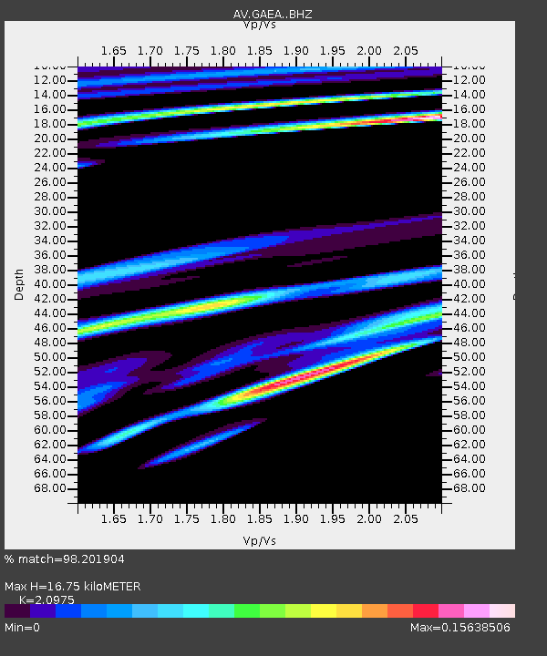
| Estimated Moho Depth: |
16.75 km |
| Estimated Crust Vp/Vs: |
2.10 |
| Assumed Crust Vp: |
6.048 km/s |
| Estimated Crust Vs: |
2.883 km/s |
| Estimated Crust Poisson's Ratio: |
0.35 |
|
| Radial Match: |
98.201904 % |
| Radial Bump: |
94 |
| Transverse Match: |
97.15649 % |
| Transverse Bump: |
108 |
| SOD ConfigId: |
27527651 |
| Insert Time: |
2022-06-02 09:28:43.032 +0000 |
| GWidth: |
2.5 |
| Max Bumps: |
400 |
| Tol: |
0.001 |
|

Signal To Noise
| Channel | StoN | STA | LTA |
| AV:GAEA: :BHZ:20220519T09:34:02.559021Z | 2.148957 | 1.49049E-5 | 6.935876E-6 |
| AV:GAEA: :BHN:20220519T09:34:02.559021Z | 2.0161881 | 2.815984E-5 | 1.3966871E-5 |
| AV:GAEA: :BHE:20220519T09:34:02.559021Z | 1.9021372 | 3.813169E-5 | 2.004676E-5 |
| Arrivals |
| Ps | 3.1 SECOND |
| PpPs | 8.3 SECOND |
| PsPs/PpSs | 11 SECOND |


