You are here: Home > Network List > US - United States National Seismic Network Stations List
> Station DGMT Dagmar, Montana, USA > Earthquake Result Viewer
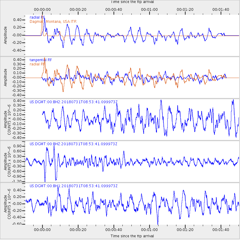
DGMT Dagmar, Montana, USA - Earthquake Result Viewer
*The percent match for this event was below the threshold and hence no stack was calculated.
| Earthquake location: |
Near East Coast Of Honshu, Japan |
| Earthquake latitude/longitude: |
37.2/141.2 |
| Earthquake time(UTC): |
2018/07/31 (212) 08:42:20 GMT |
| Earthquake Depth: |
10 km |
| Earthquake Magnitude: |
5.4 Mww |
| Earthquake Catalog/Contributor: |
NEIC PDE/us |
|
| Network: |
US United States National Seismic Network |
| Station: |
DGMT Dagmar, Montana, USA |
| Lat/Lon: |
48.47 N/104.20 W |
| Elevation: |
0.0 m |
|
| Distance: |
76.9 deg |
| Az: |
38.403 deg |
| Baz: |
311.793 deg |
| Ray Param: |
$rayparam |
*The percent match for this event was below the threshold and hence was not used in the summary stack. |
|
| Radial Match: |
54.86009 % |
| Radial Bump: |
400 |
| Transverse Match: |
54.809914 % |
| Transverse Bump: |
400 |
| SOD ConfigId: |
2778632 |
| Insert Time: |
2018-08-14 08:55:10.843 +0000 |
| GWidth: |
2.5 |
| Max Bumps: |
400 |
| Tol: |
0.001 |
|
Signal To Noise
| Channel | StoN | STA | LTA |
| US:DGMT:00:BHZ:20180731T08:53:41.099973Z | 5.405538 | 4.863185E-7 | 8.996672E-8 |
| US:DGMT:00:BH1:20180731T08:53:41.099973Z | 0.93096554 | 1.1689714E-7 | 1.2556549E-7 |
| US:DGMT:00:BH2:20180731T08:53:41.099973Z | 0.7927298 | 1.03625666E-7 | 1.3072003E-7 |
| Arrivals |
| Ps | |
| PpPs | |
| PsPs/PpSs | |


