You are here: Home > Network List > GE - GEOFON Stations List
> Station SNAA GEOFON/AWI Station Sanae, Antarctica > Earthquake Result Viewer
SNAA GEOFON/AWI Station Sanae, Antarctica - Earthquake Result Viewer
| Earthquake location: |
Macquarie Island Region |
| Earthquake latitude/longitude: |
-53.8/158.9 |
| Earthquake time(UTC): |
2022/05/19 (139) 10:13:31 GMT |
| Earthquake Depth: |
29 km |
| Earthquake Magnitude: |
7.3 Mi |
| Earthquake Catalog/Contributor: |
NEIC PDE/at |
|
| Network: |
GE GEOFON |
| Station: |
SNAA GEOFON/AWI Station Sanae, Antarctica |
| Lat/Lon: |
71.67 S/2.84 W |
| Elevation: |
846 m |
|
| Distance: |
54.2 deg |
| Az: |
187.025 deg |
| Baz: |
166.745 deg |
| Ray Param: |
0.06558539 |
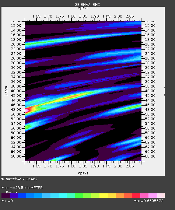
| Estimated Moho Depth: |
48.5 km |
| Estimated Crust Vp/Vs: |
1.60 |
| Assumed Crust Vp: |
6.43 km/s |
| Estimated Crust Vs: |
4.019 km/s |
| Estimated Crust Poisson's Ratio: |
0.18 |
|
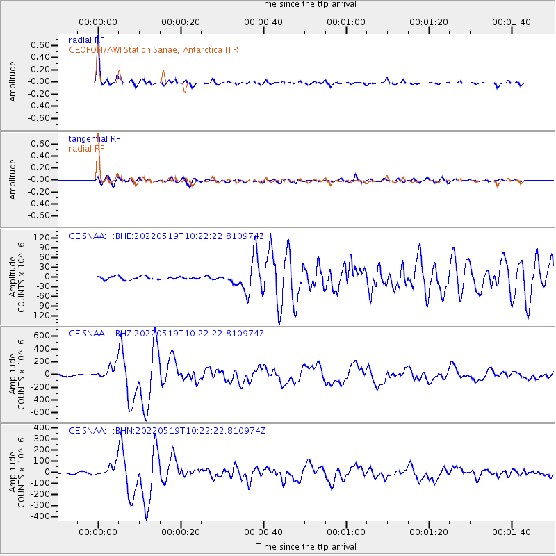
| Radial Match: |
97.26462 % |
| Radial Bump: |
341 |
| Transverse Match: |
84.38987 % |
| Transverse Bump: |
400 |
| SOD ConfigId: |
27527651 |
| Insert Time: |
2022-06-02 10:18:26.512 +0000 |
| GWidth: |
2.5 |
| Max Bumps: |
400 |
| Tol: |
0.001 |
|
Signal To Noise
| Channel | StoN | STA | LTA |
| GE:SNAA: :BHZ:20220519T10:22:22.810974Z | 13.714296 | 1.2037241E-4 | 8.777149E-6 |
| GE:SNAA: :BHN:20220519T10:22:22.810974Z | 13.026131 | 6.55241E-5 | 5.0302046E-6 |
| GE:SNAA: :BHE:20220519T10:22:22.810974Z | 2.6042833 | 1.2419817E-5 | 4.768996E-6 |
| Arrivals |
| Ps | 4.8 SECOND |
| PpPs | 18 SECOND |
| PsPs/PpSs | 23 SECOND |


