You are here: Home > Network List > US - United States National Seismic Network Stations List
> Station HAWA Hanford, Washington, USA > Earthquake Result Viewer
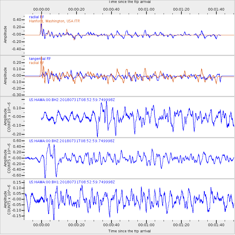
HAWA Hanford, Washington, USA - Earthquake Result Viewer
*The percent match for this event was below the threshold and hence no stack was calculated.
| Earthquake location: |
Near East Coast Of Honshu, Japan |
| Earthquake latitude/longitude: |
37.2/141.2 |
| Earthquake time(UTC): |
2018/07/31 (212) 08:42:20 GMT |
| Earthquake Depth: |
10 km |
| Earthquake Magnitude: |
5.4 Mww |
| Earthquake Catalog/Contributor: |
NEIC PDE/us |
|
| Network: |
US United States National Seismic Network |
| Station: |
HAWA Hanford, Washington, USA |
| Lat/Lon: |
46.39 N/119.53 W |
| Elevation: |
364 m |
|
| Distance: |
69.8 deg |
| Az: |
46.693 deg |
| Baz: |
302.885 deg |
| Ray Param: |
$rayparam |
*The percent match for this event was below the threshold and hence was not used in the summary stack. |
|
| Radial Match: |
68.834366 % |
| Radial Bump: |
400 |
| Transverse Match: |
53.454834 % |
| Transverse Bump: |
400 |
| SOD ConfigId: |
2778632 |
| Insert Time: |
2018-08-14 08:55:28.343 +0000 |
| GWidth: |
2.5 |
| Max Bumps: |
400 |
| Tol: |
0.001 |
|
Signal To Noise
| Channel | StoN | STA | LTA |
| US:HAWA:00:BHZ:20180731T08:52:59.749998Z | 9.857977 | 3.2556832E-7 | 3.3025877E-8 |
| US:HAWA:00:BH1:20180731T08:52:59.749998Z | 1.6304716 | 5.292207E-8 | 3.2458136E-8 |
| US:HAWA:00:BH2:20180731T08:52:59.749998Z | 2.9253736 | 9.921092E-8 | 3.3913935E-8 |
| Arrivals |
| Ps | |
| PpPs | |
| PsPs/PpSs | |


