You are here: Home > Network List > XJ98 - Side Edge of Kamchatka Subduction Zone Stations List
> Station APA Apacha > Earthquake Result Viewer
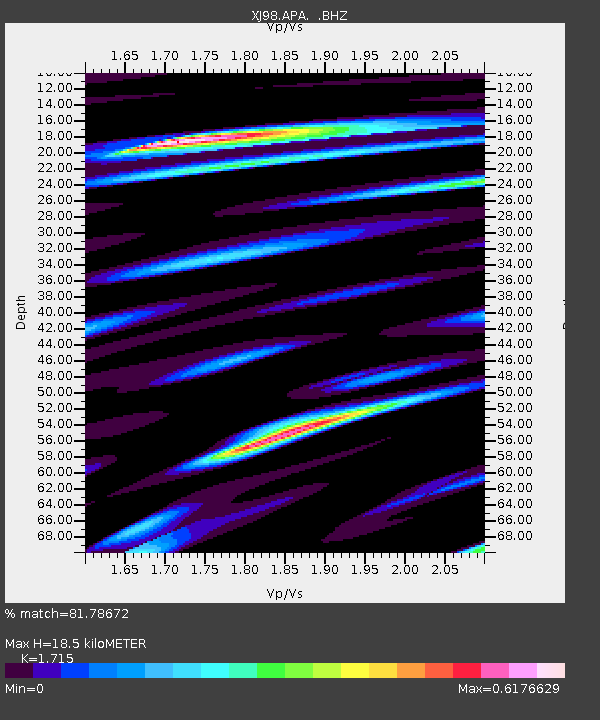
APA Apacha - Earthquake Result Viewer
| Earthquake location: |
Minahassa Peninsula, Sulawesi |
| Earthquake latitude/longitude: |
0.2/119.5 |
| Earthquake time(UTC): |
1999/02/23 (054) 07:27:56 GMT |
| Earthquake Depth: |
33 km |
| Earthquake Magnitude: |
5.6 MB, 5.8 MS |
| Earthquake Catalog/Contributor: |
WHDF/NEIC |
|
| Network: |
XJ Side Edge of Kamchatka Subduction Zone |
| Station: |
APA Apacha |
| Lat/Lon: |
52.93 N/157.13 E |
| Elevation: |
145 m |
|
| Distance: |
61.2 deg |
| Az: |
24.939 deg |
| Baz: |
224.143 deg |
| Ray Param: |
0.061003815 |
| Estimated Moho Depth: |
18.5 km |
| Estimated Crust Vp/Vs: |
1.72 |
| Assumed Crust Vp: |
6.566 km/s |
| Estimated Crust Vs: |
3.829 km/s |
| Estimated Crust Poisson's Ratio: |
0.24 |
|
| Radial Match: |
81.78672 % |
| Radial Bump: |
400 |
| Transverse Match: |
69.33633 % |
| Transverse Bump: |
400 |
| SOD ConfigId: |
4480 |
| Insert Time: |
2010-03-09 19:46:36.073 +0000 |
| GWidth: |
2.5 |
| Max Bumps: |
400 |
| Tol: |
0.001 |
|

Signal To Noise
| Channel | StoN | STA | LTA |
| XJ:APA: :BHZ:19990223T07:37:36.841011Z | 5.401004 | 1.1168594E-6 | 2.0678736E-7 |
| XJ:APA: :BHN:19990223T07:37:36.841011Z | 2.0224173 | 3.8873145E-7 | 1.922113E-7 |
| XJ:APA: :BHE:19990223T07:37:36.841011Z | 2.0140626 | 3.2461026E-7 | 1.6117188E-7 |
| Arrivals |
| Ps | 2.1 SECOND |
| PpPs | 7.3 SECOND |
| PsPs/PpSs | 9.4 SECOND |


