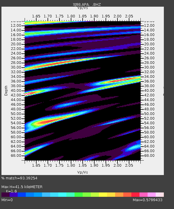
APA Apacha - Earthquake Result Viewer

Earthquake location: Western Xizang-India Border Reg.
Earthquake latitude/longitude: 30.5/79.4
Earthquake time(UTC): 1999/03/28 (087) 19:05:11 GMT
Earthquake Depth: 15 km
Earthquake Magnitude: 6.4 MB, 6.6 MS, 6.6 MW, 6.5 ME
Earthquake Catalog/Contributor: WHDF/NEIC
Network: XJ Side Edge of Kamchatka Subduction Zone
Station: APA Apacha
Lat/Lon: 52.93 N/157.13 E
Elevation: 145 m
Distance: 59.1 deg
Az: 43.571 deg
Baz: 280.735 deg
Ray Param: 0.062381916
Estimated Moho Depth: 41.5 km
Estimated Crust Vp/Vs: 1.60
Assumed Crust Vp: 6.566 km/s
Estimated Crust Vs: 4.104 km/s
Estimated Crust Poisson's Ratio: 0.18
Radial Match: 93.39254 %
Radial Bump: 400
Transverse Match: 82.63984 %
Transverse Bump: 400
SOD ConfigId: 4480
Insert Time: 2010-03-09 19:46:41.430 +0000
GWidth: 2.5
Max Bumps: 400
Tol: 0.001

Signal To Noise

ChannelStoNSTALTA
XJ:APA: :BHZ:19990328T19:14:39.769014Z11.8130894.5013653E-63.8104895E-7
XJ:APA: :BHN:19990328T19:14:39.769014Z1.43868415.4718714E-73.8033863E-7
XJ:APA: :BHE:19990328T19:14:39.769014Z3.95320341.5148762E-63.8320218E-7
Arrivals
Ps4.0 SECOND
PpPs16 SECOND
PsPs/PpSs20 SECOND