You are here: Home > Network List > LD - Lamont-Doherty Cooperative Seismographic Network Stations List
> Station GEDE Greenville, DE, USA > Earthquake Result Viewer
GEDE Greenville, DE, USA - Earthquake Result Viewer
| Earthquake location: |
Off Coast Of Central Chile |
| Earthquake latitude/longitude: |
-29.5/-72.0 |
| Earthquake time(UTC): |
2022/05/20 (140) 09:07:45 GMT |
| Earthquake Depth: |
10 km |
| Earthquake Magnitude: |
5.8 Mww |
| Earthquake Catalog/Contributor: |
NEIC PDE/us |
|
| Network: |
LD Lamont-Doherty Cooperative Seismographic Network |
| Station: |
GEDE Greenville, DE, USA |
| Lat/Lon: |
39.81 N/75.64 W |
| Elevation: |
105 m |
|
| Distance: |
69.1 deg |
| Az: |
357.037 deg |
| Baz: |
176.648 deg |
| Ray Param: |
0.055888608 |
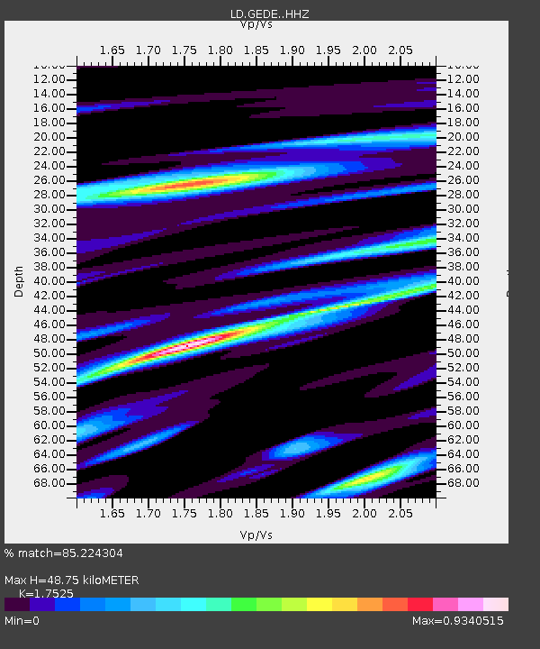
| Estimated Moho Depth: |
48.75 km |
| Estimated Crust Vp/Vs: |
1.75 |
| Assumed Crust Vp: |
6.287 km/s |
| Estimated Crust Vs: |
3.588 km/s |
| Estimated Crust Poisson's Ratio: |
0.26 |
|
| Radial Match: |
85.224304 % |
| Radial Bump: |
389 |
| Transverse Match: |
61.3489 % |
| Transverse Bump: |
400 |
| SOD ConfigId: |
27527651 |
| Insert Time: |
2022-06-03 09:19:29.144 +0000 |
| GWidth: |
2.5 |
| Max Bumps: |
400 |
| Tol: |
0.001 |
|

Signal To Noise
| Channel | StoN | STA | LTA |
| LD:GEDE: :HHZ:20220520T09:18:20.209028Z | 3.8932319 | 3.3848173E-7 | 8.6941064E-8 |
| LD:GEDE: :HHN:20220520T09:18:20.209028Z | 2.120607 | 1.959678E-7 | 9.241119E-8 |
| LD:GEDE: :HHE:20220520T09:18:20.209028Z | 0.55298895 | 4.953766E-8 | 8.958164E-8 |
| Arrivals |
| Ps | 6.1 SECOND |
| PpPs | 21 SECOND |
| PsPs/PpSs | 27 SECOND |


