You are here: Home > Network List > WY - Yellowstone Wyoming Seismic Network Stations List
> Station YPP Pitchstone Plateau, YNP, WY, USA > Earthquake Result Viewer
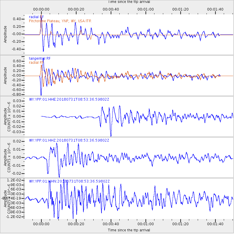
YPP Pitchstone Plateau, YNP, WY, USA - Earthquake Result Viewer
*The percent match for this event was below the threshold and hence no stack was calculated.
| Earthquake location: |
Near East Coast Of Honshu, Japan |
| Earthquake latitude/longitude: |
37.2/141.2 |
| Earthquake time(UTC): |
2018/07/31 (212) 08:42:20 GMT |
| Earthquake Depth: |
10 km |
| Earthquake Magnitude: |
5.4 Mww |
| Earthquake Catalog/Contributor: |
NEIC PDE/us |
|
| Network: |
WY Yellowstone Wyoming Seismic Network |
| Station: |
YPP Pitchstone Plateau, YNP, WY, USA |
| Lat/Lon: |
44.27 N/110.80 W |
| Elevation: |
2707 m |
|
| Distance: |
76.1 deg |
| Az: |
44.736 deg |
| Baz: |
308.503 deg |
| Ray Param: |
$rayparam |
*The percent match for this event was below the threshold and hence was not used in the summary stack. |
|
| Radial Match: |
87.0085 % |
| Radial Bump: |
400 |
| Transverse Match: |
88.77207 % |
| Transverse Bump: |
400 |
| SOD ConfigId: |
2778632 |
| Insert Time: |
2018-08-14 08:58:10.972 +0000 |
| GWidth: |
2.5 |
| Max Bumps: |
400 |
| Tol: |
0.001 |
|
Signal To Noise
| Channel | StoN | STA | LTA |
| WY:YPP:01:HHZ:20180731T08:53:36.59802Z | 6.533743 | 7.160022E-9 | 1.095853E-9 |
| WY:YPP:01:HHN:20180731T08:53:36.59802Z | 2.7884333 | 3.8697197E-9 | 1.3877756E-9 |
| WY:YPP:01:HHE:20180731T08:53:36.59802Z | 5.4655743 | 6.569641E-9 | 1.2020037E-9 |
| Arrivals |
| Ps | |
| PpPs | |
| PsPs/PpSs | |


