You are here: Home > Network List > AK - Alaska Regional Network Stations List
> Station J26L Joseph Creek, AK, USA > Earthquake Result Viewer
J26L Joseph Creek, AK, USA - Earthquake Result Viewer
| Earthquake location: |
North Of Svalbard |
| Earthquake latitude/longitude: |
84.3/0.8 |
| Earthquake time(UTC): |
2022/05/21 (141) 07:01:23 GMT |
| Earthquake Depth: |
10 km |
| Earthquake Magnitude: |
5.8 mww |
| Earthquake Catalog/Contributor: |
NEIC PDE/us |
|
| Network: |
AK Alaska Regional Network |
| Station: |
J26L Joseph Creek, AK, USA |
| Lat/Lon: |
64.50 N/143.56 W |
| Elevation: |
1144 m |
|
| Distance: |
30.4 deg |
| Az: |
330.184 deg |
| Baz: |
6.546 deg |
| Ray Param: |
0.079418324 |
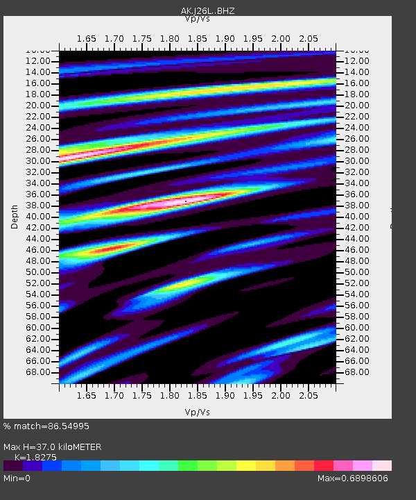
| Estimated Moho Depth: |
37.0 km |
| Estimated Crust Vp/Vs: |
1.83 |
| Assumed Crust Vp: |
6.566 km/s |
| Estimated Crust Vs: |
3.593 km/s |
| Estimated Crust Poisson's Ratio: |
0.29 |
|
| Radial Match: |
86.54995 % |
| Radial Bump: |
357 |
| Transverse Match: |
60.131042 % |
| Transverse Bump: |
400 |
| SOD ConfigId: |
27527651 |
| Insert Time: |
2022-06-04 07:04:57.924 +0000 |
| GWidth: |
2.5 |
| Max Bumps: |
400 |
| Tol: |
0.001 |
|

Signal To Noise
| Channel | StoN | STA | LTA |
| AK:J26L: :BHZ:20220521T07:07:05.82001Z | 21.315134 | 1.6569479E-6 | 7.773575E-8 |
| AK:J26L: :BHN:20220521T07:07:05.82001Z | 26.101553 | 1.0811314E-6 | 4.142019E-8 |
| AK:J26L: :BHE:20220521T07:07:05.82001Z | 2.9324472 | 1.6268045E-7 | 5.5476008E-8 |
| Arrivals |
| Ps | 5.1 SECOND |
| PpPs | 15 SECOND |
| PsPs/PpSs | 20 SECOND |


