You are here: Home > Network List > AK - Alaska Regional Network Stations List
> Station K20K Telida, AK, USA > Earthquake Result Viewer
K20K Telida, AK, USA - Earthquake Result Viewer
| Earthquake location: |
North Of Svalbard |
| Earthquake latitude/longitude: |
84.3/0.8 |
| Earthquake time(UTC): |
2022/05/21 (141) 07:01:23 GMT |
| Earthquake Depth: |
10 km |
| Earthquake Magnitude: |
5.8 mww |
| Earthquake Catalog/Contributor: |
NEIC PDE/us |
|
| Network: |
AK Alaska Regional Network |
| Station: |
K20K Telida, AK, USA |
| Lat/Lon: |
63.36 N/154.07 W |
| Elevation: |
548 m |
|
| Distance: |
32.0 deg |
| Az: |
338.875 deg |
| Baz: |
4.55 deg |
| Ray Param: |
0.0788372 |
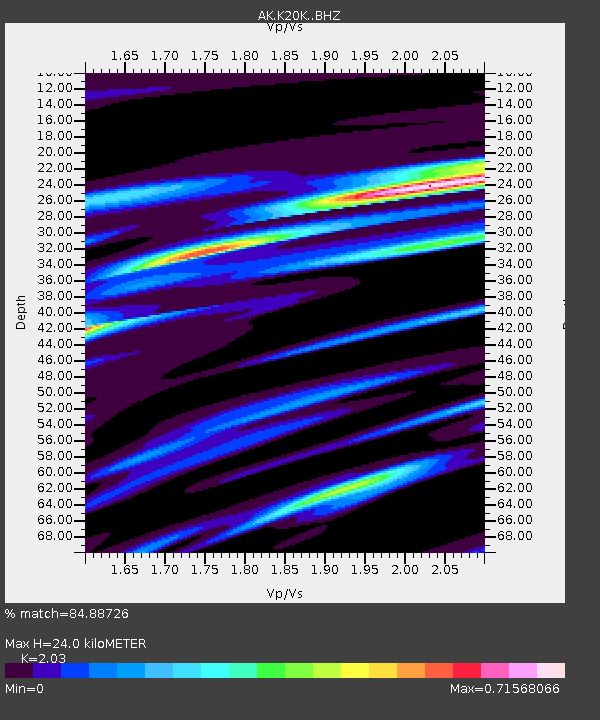
| Estimated Moho Depth: |
24.0 km |
| Estimated Crust Vp/Vs: |
2.03 |
| Assumed Crust Vp: |
6.438 km/s |
| Estimated Crust Vs: |
3.172 km/s |
| Estimated Crust Poisson's Ratio: |
0.34 |
|
| Radial Match: |
84.88726 % |
| Radial Bump: |
320 |
| Transverse Match: |
67.78705 % |
| Transverse Bump: |
400 |
| SOD ConfigId: |
27527651 |
| Insert Time: |
2022-06-04 07:05:03.772 +0000 |
| GWidth: |
2.5 |
| Max Bumps: |
400 |
| Tol: |
0.001 |
|

Signal To Noise
| Channel | StoN | STA | LTA |
| AK:K20K: :BHZ:20220521T07:07:19.79999Z | 15.131504 | 1.7759419E-6 | 1.1736717E-7 |
| AK:K20K: :BHN:20220521T07:07:19.79999Z | 13.927362 | 1.3497512E-6 | 9.6913624E-8 |
| AK:K20K: :BHE:20220521T07:07:19.79999Z | 2.234245 | 1.9855636E-7 | 8.886955E-8 |
| Arrivals |
| Ps | 4.1 SECOND |
| PpPs | 11 SECOND |
| PsPs/PpSs | 15 SECOND |


