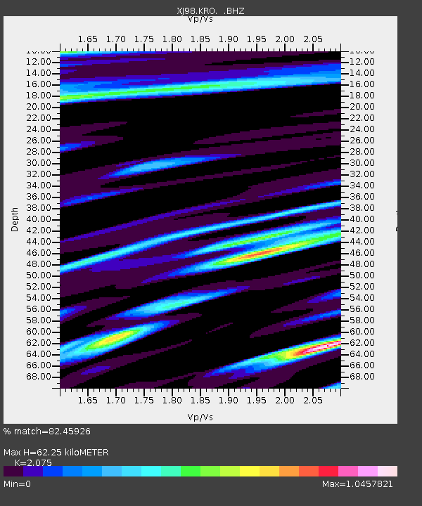
KRO Kronoki - Earthquake Result Viewer

Earthquake location: Vanuatu Islands
Earthquake latitude/longitude: -13.6/166.8
Earthquake time(UTC): 1998/09/21 (264) 12:09:39 GMT
Earthquake Depth: 33 km
Earthquake Magnitude: 6.0 MB, 6.3 MS, 6.4 UNKNOWN, 6.3 MW
Earthquake Catalog/Contributor: WHDF/NEIC
Network: XJ Side Edge of Kamchatka Subduction Zone
Station: KRO Kronoki
Lat/Lon: 54.59 N/161.13 E
Elevation: 64 m
Distance: 68.1 deg
Az: 356.454 deg
Baz: 174.069 deg
Ray Param: 0.05649478
Estimated Moho Depth: 62.25 km
Estimated Crust Vp/Vs: 2.08
Assumed Crust Vp: 6.438 km/s
Estimated Crust Vs: 3.103 km/s
Estimated Crust Poisson's Ratio: 0.35
Radial Match: 82.45926 %
Radial Bump: 400
Transverse Match: 70.77933 %
Transverse Bump: 400
SOD ConfigId: 4480
Insert Time: 2010-03-09 19:52:01.294 +0000
GWidth: 2.5
Max Bumps: 400
Tol: 0.001

Signal To Noise

ChannelStoNSTALTA
XJ:KRO: :BHZ:19980921T12:20:05.042017Z8.4442852.5706368E-63.0442322E-7
XJ:KRO: :BHN:19980921T12:20:05.042017Z2.75418021.2478284E-64.5306712E-7
XJ:KRO: :BHE:19980921T12:20:05.042017Z1.154485.017216E-74.345867E-7
Arrivals
Ps11 SECOND
PpPs29 SECOND
PsPs/PpSs40 SECOND