You are here: Home > Network List > C0 - Colorado Geological Survey Seismic Network Stations List
> Station LAMA Lamar Colorado > Earthquake Result Viewer
LAMA Lamar Colorado - Earthquake Result Viewer
| Earthquake location: |
North Of Svalbard |
| Earthquake latitude/longitude: |
84.3/0.8 |
| Earthquake time(UTC): |
2022/05/21 (141) 07:01:23 GMT |
| Earthquake Depth: |
10 km |
| Earthquake Magnitude: |
5.8 mww |
| Earthquake Catalog/Contributor: |
NEIC PDE/us |
|
| Network: |
C0 Colorado Geological Survey Seismic Network |
| Station: |
LAMA Lamar Colorado |
| Lat/Lon: |
38.27 N/102.65 W |
| Elevation: |
1182 m |
|
| Distance: |
53.4 deg |
| Az: |
287.67 deg |
| Baz: |
6.9 deg |
| Ray Param: |
0.06610817 |
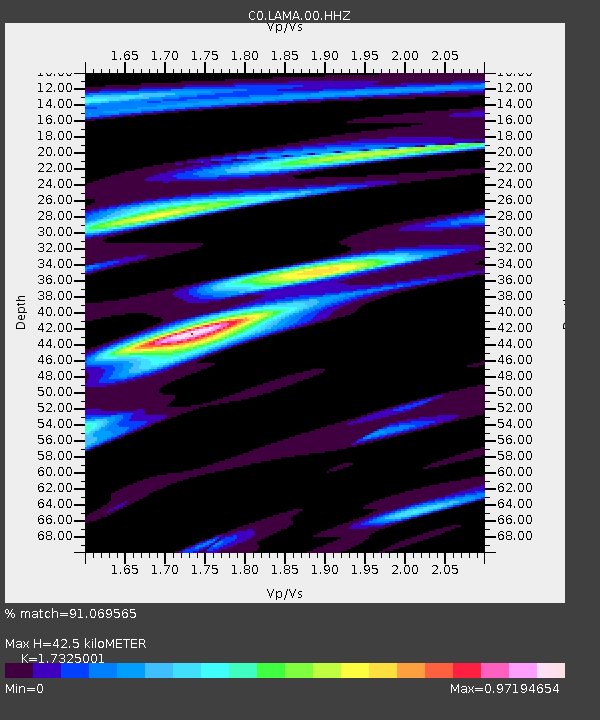
| Estimated Moho Depth: |
42.5 km |
| Estimated Crust Vp/Vs: |
1.73 |
| Assumed Crust Vp: |
6.242 km/s |
| Estimated Crust Vs: |
3.603 km/s |
| Estimated Crust Poisson's Ratio: |
0.25 |
|
| Radial Match: |
91.069565 % |
| Radial Bump: |
357 |
| Transverse Match: |
68.12756 % |
| Transverse Bump: |
400 |
| SOD ConfigId: |
27527651 |
| Insert Time: |
2022-06-04 07:10:58.944 +0000 |
| GWidth: |
2.5 |
| Max Bumps: |
400 |
| Tol: |
0.001 |
|

Signal To Noise
| Channel | StoN | STA | LTA |
| C0:LAMA:00:HHZ:20220521T07:10:12.882998Z | 18.756157 | 1.0000069E-6 | 5.33162E-8 |
| C0:LAMA:00:HHN:20220521T07:10:12.882998Z | 6.8515935 | 5.525114E-7 | 8.0639836E-8 |
| C0:LAMA:00:HHE:20220521T07:10:12.882998Z | 2.6306865 | 2.0904032E-7 | 7.9462275E-8 |
| Arrivals |
| Ps | 5.3 SECOND |
| PpPs | 18 SECOND |
| PsPs/PpSs | 23 SECOND |


