You are here: Home > Network List > C8 - Canadian Seismic Research Network () Stations List
> Station GRIB Gribbell Island, BC, CA > Earthquake Result Viewer
GRIB Gribbell Island, BC, CA - Earthquake Result Viewer
| Earthquake location: |
North Of Svalbard |
| Earthquake latitude/longitude: |
84.3/0.8 |
| Earthquake time(UTC): |
2022/05/21 (141) 07:01:23 GMT |
| Earthquake Depth: |
10 km |
| Earthquake Magnitude: |
5.8 mww |
| Earthquake Catalog/Contributor: |
NEIC PDE/us |
|
| Network: |
C8 Canadian Seismic Research Network () |
| Station: |
GRIB Gribbell Island, BC, CA |
| Lat/Lon: |
53.34 N/129.14 W |
| Elevation: |
418 m |
|
| Distance: |
40.7 deg |
| Az: |
315.201 deg |
| Baz: |
6.696 deg |
| Ray Param: |
0.07424456 |
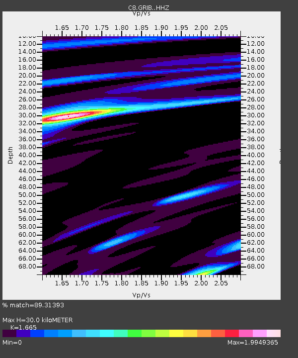
| Estimated Moho Depth: |
30.0 km |
| Estimated Crust Vp/Vs: |
1.66 |
| Assumed Crust Vp: |
6.545 km/s |
| Estimated Crust Vs: |
3.931 km/s |
| Estimated Crust Poisson's Ratio: |
0.22 |
|
| Radial Match: |
89.31393 % |
| Radial Bump: |
303 |
| Transverse Match: |
89.11602 % |
| Transverse Bump: |
240 |
| SOD ConfigId: |
27527651 |
| Insert Time: |
2022-06-04 07:11:11.354 +0000 |
| GWidth: |
2.5 |
| Max Bumps: |
400 |
| Tol: |
0.001 |
|
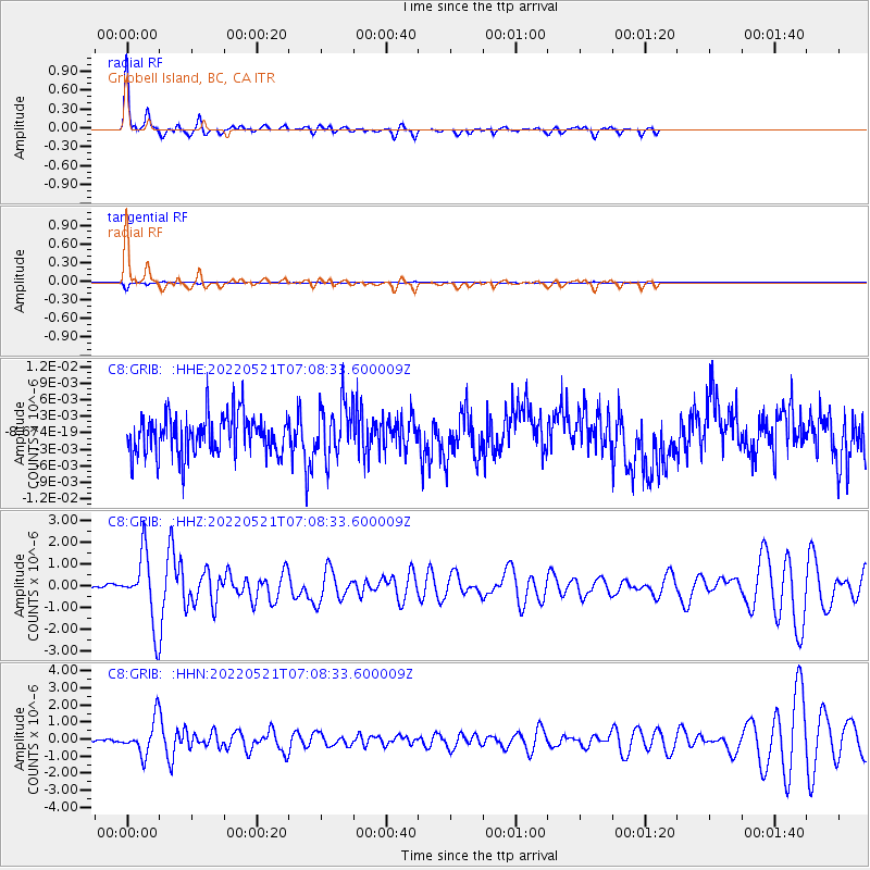
Signal To Noise
| Channel | StoN | STA | LTA |
| C8:GRIB: :HHZ:20220521T07:08:33.600009Z | 14.028463 | 1.55532E-6 | 1.1086887E-7 |
| C8:GRIB: :HHN:20220521T07:08:33.600009Z | 10.386678 | 9.83615E-7 | 9.469968E-8 |
| C8:GRIB: :HHE:20220521T07:08:33.600009Z | 1.3496994 | 4.873759E-9 | 3.6109962E-9 |
| Arrivals |
| Ps | 3.3 SECOND |
| PpPs | 11 SECOND |
| PsPs/PpSs | 15 SECOND |


