You are here: Home > Network List > CC - Cascade Chain Volcano Monitoring Stations List
> Station PR04 Puyallup River 04 > Earthquake Result Viewer
PR04 Puyallup River 04 - Earthquake Result Viewer
| Earthquake location: |
North Of Svalbard |
| Earthquake latitude/longitude: |
84.3/0.8 |
| Earthquake time(UTC): |
2022/05/21 (141) 07:01:23 GMT |
| Earthquake Depth: |
10 km |
| Earthquake Magnitude: |
5.8 mww |
| Earthquake Catalog/Contributor: |
NEIC PDE/us |
|
| Network: |
CC Cascade Chain Volcano Monitoring |
| Station: |
PR04 Puyallup River 04 |
| Lat/Lon: |
46.93 N/121.99 W |
| Elevation: |
908 m |
|
| Distance: |
46.5 deg |
| Az: |
307.503 deg |
| Baz: |
6.596 deg |
| Ray Param: |
0.07058348 |
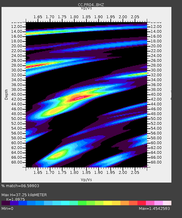
| Estimated Moho Depth: |
37.25 km |
| Estimated Crust Vp/Vs: |
1.90 |
| Assumed Crust Vp: |
6.597 km/s |
| Estimated Crust Vs: |
3.477 km/s |
| Estimated Crust Poisson's Ratio: |
0.31 |
|
| Radial Match: |
86.59903 % |
| Radial Bump: |
400 |
| Transverse Match: |
76.217384 % |
| Transverse Bump: |
400 |
| SOD ConfigId: |
27527651 |
| Insert Time: |
2022-06-04 07:12:29.794 +0000 |
| GWidth: |
2.5 |
| Max Bumps: |
400 |
| Tol: |
0.001 |
|

Signal To Noise
| Channel | StoN | STA | LTA |
| CC:PR04: :BHZ:20220521T07:09:20.579989Z | 18.612425 | 2.2152506E-6 | 1.1901999E-7 |
| CC:PR04: :BHN:20220521T07:09:20.579989Z | 12.384289 | 1.4979238E-6 | 1.2095356E-7 |
| CC:PR04: :BHE:20220521T07:09:20.579989Z | 5.6542225 | 5.670923E-7 | 1.0029537E-7 |
| Arrivals |
| Ps | 5.4 SECOND |
| PpPs | 15 SECOND |
| PsPs/PpSs | 21 SECOND |


