You are here: Home > Network List > GM - US Geological Survey Networks Stations List
> Station NMP25 New Mexico Permian - Site# W2S5 > Earthquake Result Viewer
NMP25 New Mexico Permian - Site# W2S5 - Earthquake Result Viewer
| Earthquake location: |
North Of Svalbard |
| Earthquake latitude/longitude: |
84.3/0.8 |
| Earthquake time(UTC): |
2022/05/21 (141) 07:01:23 GMT |
| Earthquake Depth: |
10 km |
| Earthquake Magnitude: |
5.8 mww |
| Earthquake Catalog/Contributor: |
NEIC PDE/us |
|
| Network: |
GM US Geological Survey Networks |
| Station: |
NMP25 New Mexico Permian - Site# W2S5 |
| Lat/Lon: |
32.34 N/103.86 W |
| Elevation: |
983 m |
|
| Distance: |
59.4 deg |
| Az: |
288.031 deg |
| Baz: |
6.4 deg |
| Ray Param: |
0.062188547 |
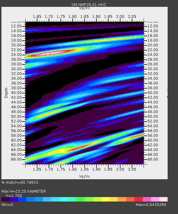
| Estimated Moho Depth: |
23.25 km |
| Estimated Crust Vp/Vs: |
1.71 |
| Assumed Crust Vp: |
6.129 km/s |
| Estimated Crust Vs: |
3.595 km/s |
| Estimated Crust Poisson's Ratio: |
0.24 |
|
| Radial Match: |
80.76923 % |
| Radial Bump: |
400 |
| Transverse Match: |
15.507007 % |
| Transverse Bump: |
400 |
| SOD ConfigId: |
27527651 |
| Insert Time: |
2022-06-04 07:20:38.466 +0000 |
| GWidth: |
2.5 |
| Max Bumps: |
400 |
| Tol: |
0.001 |
|

Signal To Noise
| Channel | StoN | STA | LTA |
| GM:NMP25:01:HHZ:20220521T07:10:55.520022Z | 27.44103 | 2.357404E-6 | 8.590799E-8 |
| GM:NMP25:01:HHN:20220521T07:10:55.520022Z | 5.109918 | 9.4014104E-7 | 1.8398357E-7 |
| GM:NMP25:01:HHE:20220521T07:10:55.520022Z | 0.49999166 | 2.8378926E-7 | 5.67588E-7 |
| Arrivals |
| Ps | 2.8 SECOND |
| PpPs | 9.8 SECOND |
| PsPs/PpSs | 13 SECOND |


