You are here: Home > Network List > IW - Intermountain West Stations List
> Station MOOW Moose Ponds, Wyoming, USA > Earthquake Result Viewer
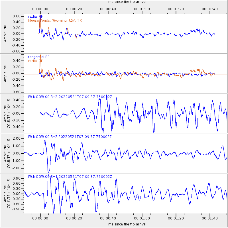
MOOW Moose Ponds, Wyoming, USA - Earthquake Result Viewer
*The percent match for this event was below the threshold and hence no stack was calculated.
| Earthquake location: |
North Of Svalbard |
| Earthquake latitude/longitude: |
84.3/0.8 |
| Earthquake time(UTC): |
2022/05/21 (141) 07:01:23 GMT |
| Earthquake Depth: |
10 km |
| Earthquake Magnitude: |
5.8 mww |
| Earthquake Catalog/Contributor: |
NEIC PDE/us |
|
| Network: |
IW Intermountain West |
| Station: |
MOOW Moose Ponds, Wyoming, USA |
| Lat/Lon: |
43.75 N/110.74 W |
| Elevation: |
2128 m |
|
| Distance: |
48.8 deg |
| Az: |
296.34 deg |
| Baz: |
7.049 deg |
| Ray Param: |
$rayparam |
*The percent match for this event was below the threshold and hence was not used in the summary stack. |
|
| Radial Match: |
74.8679 % |
| Radial Bump: |
400 |
| Transverse Match: |
62.05456 % |
| Transverse Bump: |
400 |
| SOD ConfigId: |
27527651 |
| Insert Time: |
2022-06-04 07:23:43.711 +0000 |
| GWidth: |
2.5 |
| Max Bumps: |
400 |
| Tol: |
0.001 |
|
Signal To Noise
| Channel | StoN | STA | LTA |
| IW:MOOW:00:BHZ:20220521T07:09:37.750002Z | 9.930819 | 1.0570898E-6 | 1.06445384E-7 |
| IW:MOOW:00:BH1:20220521T07:09:37.750002Z | 5.4754176 | 4.5571795E-7 | 8.322981E-8 |
| IW:MOOW:00:BH2:20220521T07:09:37.750002Z | 2.7350557 | 1.7876533E-7 | 6.5360766E-8 |
| Arrivals |
| Ps | |
| PpPs | |
| PsPs/PpSs | |


