You are here: Home > Network List > OK - Oklahoma Seismic Network Stations List
> Station DEOK Depew, Oklahoma, USA > Earthquake Result Viewer
DEOK Depew, Oklahoma, USA - Earthquake Result Viewer
| Earthquake location: |
North Of Svalbard |
| Earthquake latitude/longitude: |
84.3/0.8 |
| Earthquake time(UTC): |
2022/05/21 (141) 07:01:23 GMT |
| Earthquake Depth: |
10 km |
| Earthquake Magnitude: |
5.8 mww |
| Earthquake Catalog/Contributor: |
NEIC PDE/us |
|
| Network: |
OK Oklahoma Seismic Network |
| Station: |
DEOK Depew, Oklahoma, USA |
| Lat/Lon: |
35.84 N/96.50 W |
| Elevation: |
291 m |
|
| Distance: |
55.3 deg |
| Az: |
281.304 deg |
| Baz: |
6.879 deg |
| Ray Param: |
0.064909264 |
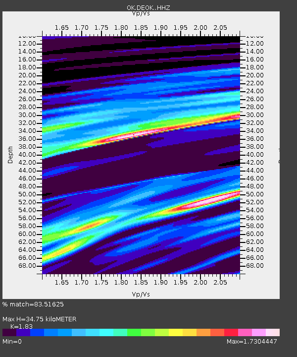
| Estimated Moho Depth: |
34.75 km |
| Estimated Crust Vp/Vs: |
1.83 |
| Assumed Crust Vp: |
6.426 km/s |
| Estimated Crust Vs: |
3.512 km/s |
| Estimated Crust Poisson's Ratio: |
0.29 |
|
| Radial Match: |
83.51625 % |
| Radial Bump: |
400 |
| Transverse Match: |
81.96548 % |
| Transverse Bump: |
400 |
| SOD ConfigId: |
27527651 |
| Insert Time: |
2022-06-04 07:33:19.028 +0000 |
| GWidth: |
2.5 |
| Max Bumps: |
400 |
| Tol: |
0.001 |
|

Signal To Noise
| Channel | StoN | STA | LTA |
| OK:DEOK: :HHZ:20220521T07:10:26.08002Z | 9.651905 | 2.3654193E-6 | 2.4507278E-7 |
| OK:DEOK: :HHN:20220521T07:10:26.08002Z | 5.511606 | 1.4577545E-6 | 2.6448814E-7 |
| OK:DEOK: :HHE:20220521T07:10:26.08002Z | 1.2822534 | 2.1538858E-8 | 1.6797662E-8 |
| Arrivals |
| Ps | 4.7 SECOND |
| PpPs | 15 SECOND |
| PsPs/PpSs | 19 SECOND |


