You are here: Home > Network List > TX - Texas Seismological Network Stations List
> Station PB08 Permian Basin 08 > Earthquake Result Viewer
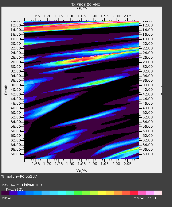
PB08 Permian Basin 08 - Earthquake Result Viewer
| Earthquake location: |
North Of Svalbard |
| Earthquake latitude/longitude: |
84.3/0.8 |
| Earthquake time(UTC): |
2022/05/21 (141) 07:01:23 GMT |
| Earthquake Depth: |
10 km |
| Earthquake Magnitude: |
5.8 mww |
| Earthquake Catalog/Contributor: |
NEIC PDE/us |
|
| Network: |
TX Texas Seismological Network |
| Station: |
PB08 Permian Basin 08 |
| Lat/Lon: |
30.89 N/102.91 W |
| Elevation: |
926 m |
|
| Distance: |
60.8 deg |
| Az: |
286.915 deg |
| Baz: |
6.341 deg |
| Ray Param: |
0.061316244 |
| Estimated Moho Depth: |
25.0 km |
| Estimated Crust Vp/Vs: |
1.91 |
| Assumed Crust Vp: |
6.121 km/s |
| Estimated Crust Vs: |
3.2 km/s |
| Estimated Crust Poisson's Ratio: |
0.31 |
|
| Radial Match: |
90.55267 % |
| Radial Bump: |
400 |
| Transverse Match: |
84.87026 % |
| Transverse Bump: |
378 |
| SOD ConfigId: |
27527651 |
| Insert Time: |
2022-06-04 07:38:50.072 +0000 |
| GWidth: |
2.5 |
| Max Bumps: |
400 |
| Tol: |
0.001 |
|

Signal To Noise
| Channel | StoN | STA | LTA |
| TX:PB08:00:HHZ:20220521T07:11:04.710024Z | 8.803147 | 1.8444829E-6 | 2.095254E-7 |
| TX:PB08:00:HH1:20220521T07:11:04.710024Z | 3.8643086 | 5.4462913E-7 | 1.4093833E-7 |
| TX:PB08:00:HH2:20220521T07:11:04.710024Z | 4.500913 | 3.5855453E-7 | 7.966262E-8 |
| Arrivals |
| Ps | 3.9 SECOND |
| PpPs | 11 SECOND |
| PsPs/PpSs | 15 SECOND |


