You are here: Home > Network List > US - United States National Seismic Network Stations List
> Station MSO Missoula, Montana, USA > Earthquake Result Viewer
MSO Missoula, Montana, USA - Earthquake Result Viewer

| Earthquake location: |
North Of Svalbard |
| Earthquake latitude/longitude: |
84.3/0.8 |
| Earthquake time(UTC): |
2022/05/21 (141) 07:01:23 GMT |
| Earthquake Depth: |
10 km |
| Earthquake Magnitude: |
5.8 mww |
| Earthquake Catalog/Contributor: |
NEIC PDE/us |
|
| Network: |
US United States National Seismic Network |
| Station: |
MSO Missoula, Montana, USA |
| Lat/Lon: |
46.83 N/113.94 W |
| Elevation: |
1264 m |
|
| Distance: |
46.0 deg |
| Az: |
299.901 deg |
| Baz: |
7.198 deg |
| Ray Param: |
0.07094363 |
| Estimated Moho Depth: |
39.0 km |
| Estimated Crust Vp/Vs: |
1.68 |
| Assumed Crust Vp: |
6.353 km/s |
| Estimated Crust Vs: |
3.782 km/s |
| Estimated Crust Poisson's Ratio: |
0.23 |
|
| Radial Match: |
92.37185 % |
| Radial Bump: |
345 |
| Transverse Match: |
83.40444 % |
| Transverse Bump: |
400 |
| SOD ConfigId: |
27527651 |
| Insert Time: |
2022-06-04 07:41:45.329 +0000 |
| GWidth: |
2.5 |
| Max Bumps: |
400 |
| Tol: |
0.001 |
|
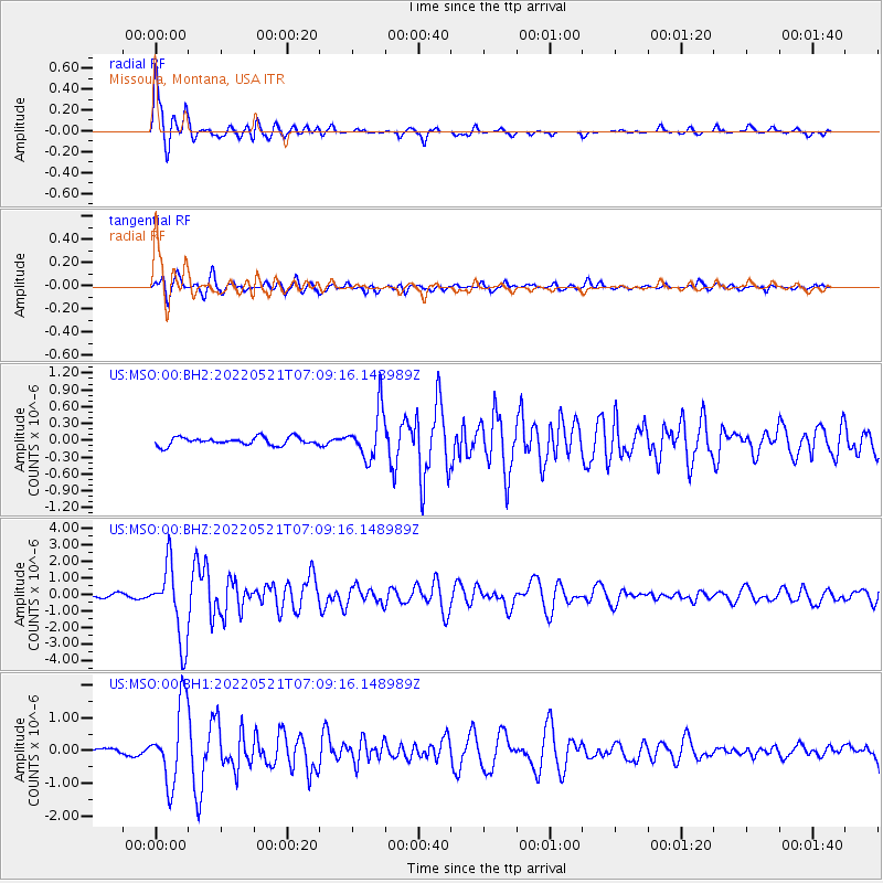
Signal To Noise
| Channel | StoN | STA | LTA |
| US:MSO:00:BHZ:20220521T07:09:16.148989Z | 16.557598 | 2.2483684E-6 | 1.3579074E-7 |
| US:MSO:00:BH1:20220521T07:09:16.148989Z | 13.0962 | 1.1846389E-6 | 9.045669E-8 |
| US:MSO:00:BH2:20220521T07:09:16.148989Z | 6.0019 | 4.245509E-7 | 7.073608E-8 |
| Arrivals |
| Ps | 4.5 SECOND |
| PpPs | 15 SECOND |
| PsPs/PpSs | 20 SECOND |


