You are here: Home > Network List > PF - Volcanologic Network of Piton de Fournaise-OVPF Stations List
> Station GBS Grandes pentes coulee 1943 bas > Earthquake Result Viewer
GBS Grandes pentes coulee 1943 bas - Earthquake Result Viewer
| Earthquake location: |
Sumbawa Region, Indonesia |
| Earthquake latitude/longitude: |
-8.3/116.5 |
| Earthquake time(UTC): |
2018/08/05 (217) 11:46:34 GMT |
| Earthquake Depth: |
10 km |
| Earthquake Magnitude: |
7.0 Mww |
| Earthquake Catalog/Contributor: |
NEIC PDE/us |
|
| Network: |
PF Volcanologic Network of Piton de Fournaise-OVPF |
| Station: |
GBS Grandes pentes coulee 1943 bas |
| Lat/Lon: |
21.27 S/55.78 E |
| Elevation: |
471 m |
|
| Distance: |
59.8 deg |
| Az: |
250.262 deg |
| Baz: |
87.24 deg |
| Ray Param: |
0.061974347 |
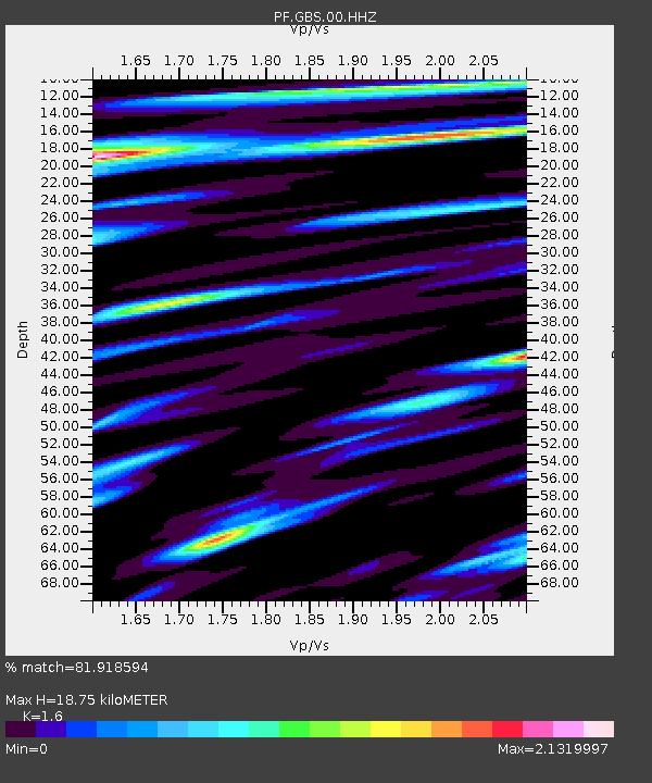
| Estimated Moho Depth: |
18.75 km |
| Estimated Crust Vp/Vs: |
1.60 |
| Assumed Crust Vp: |
4.73 km/s |
| Estimated Crust Vs: |
2.956 km/s |
| Estimated Crust Poisson's Ratio: |
0.18 |
|
| Radial Match: |
81.918594 % |
| Radial Bump: |
400 |
| Transverse Match: |
69.9936 % |
| Transverse Bump: |
400 |
| SOD ConfigId: |
2778632 |
| Insert Time: |
2018-08-19 11:51:29.327 +0000 |
| GWidth: |
2.5 |
| Max Bumps: |
400 |
| Tol: |
0.001 |
|
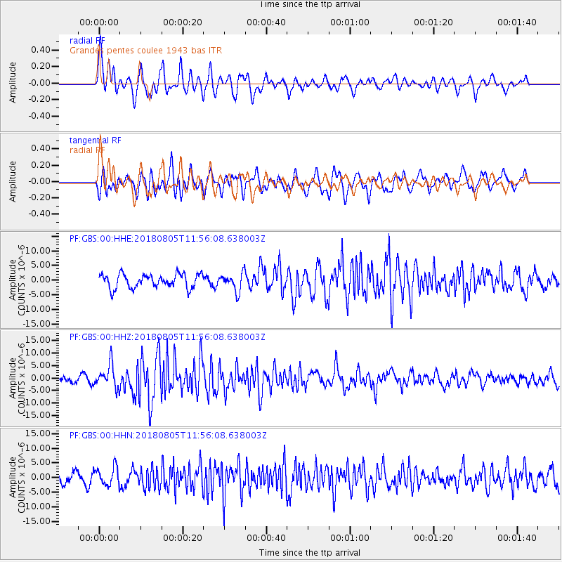
Signal To Noise
| Channel | StoN | STA | LTA |
| PF:GBS:00:HHZ:20180805T11:56:08.638003Z | 4.049508 | 4.765485E-6 | 1.1768058E-6 |
| PF:GBS:00:HHN:20180805T11:56:08.638003Z | 1.4197383 | 3.1118295E-6 | 2.1918331E-6 |
| PF:GBS:00:HHE:20180805T11:56:08.638003Z | 1.3234044 | 3.1668915E-6 | 2.3929883E-6 |
| Arrivals |
| Ps | 2.4 SECOND |
| PpPs | 10 SECOND |
| PsPs/PpSs | 12 SECOND |


