You are here: Home > Network List > AK - Alaska Regional Network Stations List
> Station F21K Alatna River, AK, USA > Earthquake Result Viewer
F21K Alatna River, AK, USA - Earthquake Result Viewer
| Earthquake location: |
Mindoro, Philippines |
| Earthquake latitude/longitude: |
14.0/120.7 |
| Earthquake time(UTC): |
2022/05/21 (141) 21:50:48 GMT |
| Earthquake Depth: |
136 km |
| Earthquake Magnitude: |
6.1 mww |
| Earthquake Catalog/Contributor: |
NEIC PDE/us |
|
| Network: |
AK Alaska Regional Network |
| Station: |
F21K Alatna River, AK, USA |
| Lat/Lon: |
67.22 N/153.48 W |
| Elevation: |
597 m |
|
| Distance: |
75.6 deg |
| Az: |
23.633 deg |
| Baz: |
271.681 deg |
| Ray Param: |
0.051199615 |
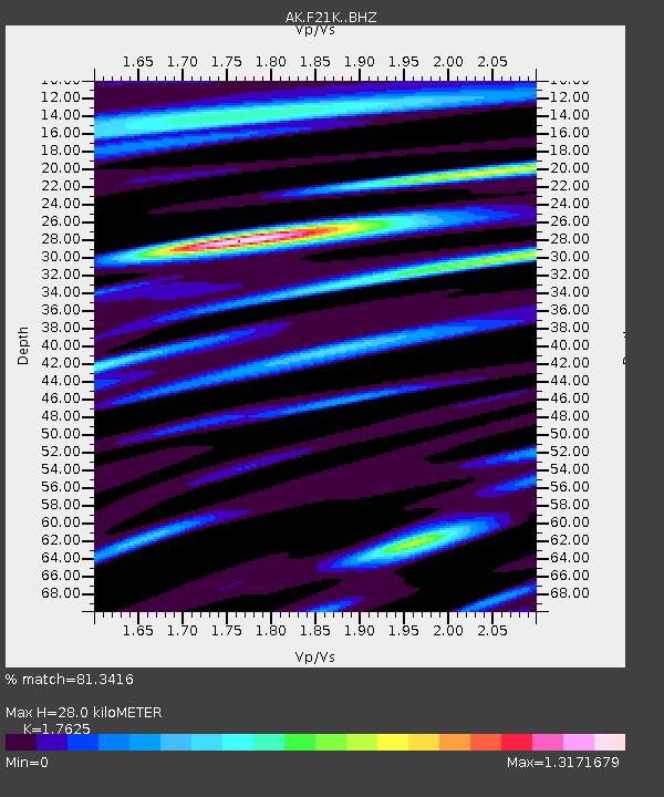
| Estimated Moho Depth: |
28.0 km |
| Estimated Crust Vp/Vs: |
1.76 |
| Assumed Crust Vp: |
6.455 km/s |
| Estimated Crust Vs: |
3.663 km/s |
| Estimated Crust Poisson's Ratio: |
0.26 |
|
| Radial Match: |
81.3416 % |
| Radial Bump: |
400 |
| Transverse Match: |
65.7008 % |
| Transverse Bump: |
400 |
| SOD ConfigId: |
27527651 |
| Insert Time: |
2022-06-04 21:55:13.305 +0000 |
| GWidth: |
2.5 |
| Max Bumps: |
400 |
| Tol: |
0.001 |
|

Signal To Noise
| Channel | StoN | STA | LTA |
| AK:F21K: :BHZ:20220521T22:01:47.85999Z | 9.5653715 | 7.2395545E-7 | 7.568504E-8 |
| AK:F21K: :BHN:20220521T22:01:47.85999Z | 1.7078006 | 8.487733E-8 | 4.9699786E-8 |
| AK:F21K: :BHE:20220521T22:01:47.85999Z | 8.660157 | 3.5172386E-7 | 4.0614026E-8 |
| Arrivals |
| Ps | 3.4 SECOND |
| PpPs | 12 SECOND |
| PsPs/PpSs | 15 SECOND |


