You are here: Home > Network List > AK - Alaska Regional Network Stations List
> Station H23K Yukon River, AK, USA > Earthquake Result Viewer
H23K Yukon River, AK, USA - Earthquake Result Viewer
| Earthquake location: |
Mindoro, Philippines |
| Earthquake latitude/longitude: |
14.0/120.7 |
| Earthquake time(UTC): |
2022/05/21 (141) 21:50:48 GMT |
| Earthquake Depth: |
136 km |
| Earthquake Magnitude: |
6.1 mww |
| Earthquake Catalog/Contributor: |
NEIC PDE/us |
|
| Network: |
AK Alaska Regional Network |
| Station: |
H23K Yukon River, AK, USA |
| Lat/Lon: |
65.83 N/149.54 W |
| Elevation: |
617 m |
|
| Distance: |
77.3 deg |
| Az: |
24.97 deg |
| Baz: |
275.604 deg |
| Ray Param: |
0.050097432 |
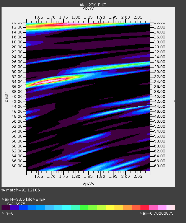
| Estimated Moho Depth: |
33.5 km |
| Estimated Crust Vp/Vs: |
1.70 |
| Assumed Crust Vp: |
6.566 km/s |
| Estimated Crust Vs: |
3.868 km/s |
| Estimated Crust Poisson's Ratio: |
0.23 |
|
| Radial Match: |
91.12185 % |
| Radial Bump: |
400 |
| Transverse Match: |
72.22781 % |
| Transverse Bump: |
400 |
| SOD ConfigId: |
27527651 |
| Insert Time: |
2022-06-04 21:55:39.405 +0000 |
| GWidth: |
2.5 |
| Max Bumps: |
400 |
| Tol: |
0.001 |
|

Signal To Noise
| Channel | StoN | STA | LTA |
| AK:H23K: :BHZ:20220521T22:01:57.200017Z | 13.672642 | 1.3571237E-6 | 9.925834E-8 |
| AK:H23K: :BHN:20220521T22:01:57.200017Z | 1.523496 | 1.8249845E-7 | 1.1978926E-7 |
| AK:H23K: :BHE:20220521T22:01:57.200017Z | 8.983612 | 4.2997806E-7 | 4.786249E-8 |
| Arrivals |
| Ps | 3.7 SECOND |
| PpPs | 13 SECOND |
| PsPs/PpSs | 17 SECOND |


