You are here: Home > Network List > XJ98 - Side Edge of Kamchatka Subduction Zone Stations List
> Station UHR Ust-Haryuzovo > Earthquake Result Viewer
UHR Ust-Haryuzovo - Earthquake Result Viewer
| Earthquake location: |
Fiji Islands Region |
| Earthquake latitude/longitude: |
-21.6/-176.4 |
| Earthquake time(UTC): |
1998/12/27 (361) 00:38:26 GMT |
| Earthquake Depth: |
144 km |
| Earthquake Magnitude: |
6.1 MB, 6.9 UNKNOWN, 6.6 ME |
| Earthquake Catalog/Contributor: |
WHDF/NEIC |
|
| Network: |
XJ Side Edge of Kamchatka Subduction Zone |
| Station: |
UHR Ust-Haryuzovo |
| Lat/Lon: |
57.09 N/156.77 E |
| Elevation: |
118 m |
|
| Distance: |
81.6 deg |
| Az: |
345.566 deg |
| Baz: |
154.856 deg |
| Ray Param: |
0.047127906 |
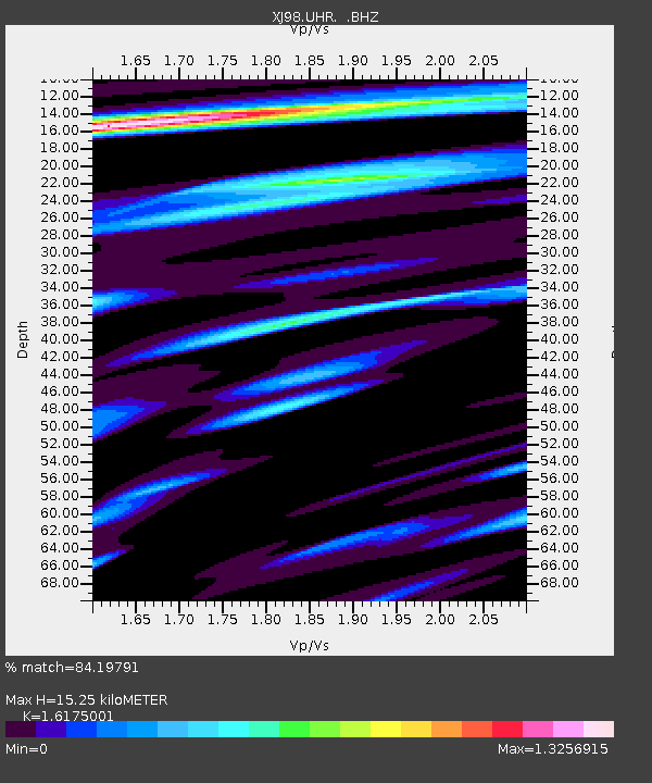
| Estimated Moho Depth: |
15.25 km |
| Estimated Crust Vp/Vs: |
1.62 |
| Assumed Crust Vp: |
6.438 km/s |
| Estimated Crust Vs: |
3.98 km/s |
| Estimated Crust Poisson's Ratio: |
0.19 |
|
| Radial Match: |
84.19791 % |
| Radial Bump: |
400 |
| Transverse Match: |
70.509094 % |
| Transverse Bump: |
400 |
| SOD ConfigId: |
4480 |
| Insert Time: |
2010-03-09 19:59:55.182 +0000 |
| GWidth: |
2.5 |
| Max Bumps: |
400 |
| Tol: |
0.001 |
|

Signal To Noise
| Channel | StoN | STA | LTA |
| XJ:UHR: :BHZ:19981227T00:49:57.468005Z | 16.481174 | 7.161283E-6 | 4.3451294E-7 |
| XJ:UHR: :BHN:19981227T00:49:57.468005Z | 2.6524622 | 1.9758484E-6 | 7.44911E-7 |
| XJ:UHR: :BHE:19981227T00:49:57.468005Z | 1.9581641 | 1.1567021E-6 | 5.907075E-7 |
| Arrivals |
| Ps | 1.5 SECOND |
| PpPs | 6.0 SECOND |
| PsPs/PpSs | 7.5 SECOND |


