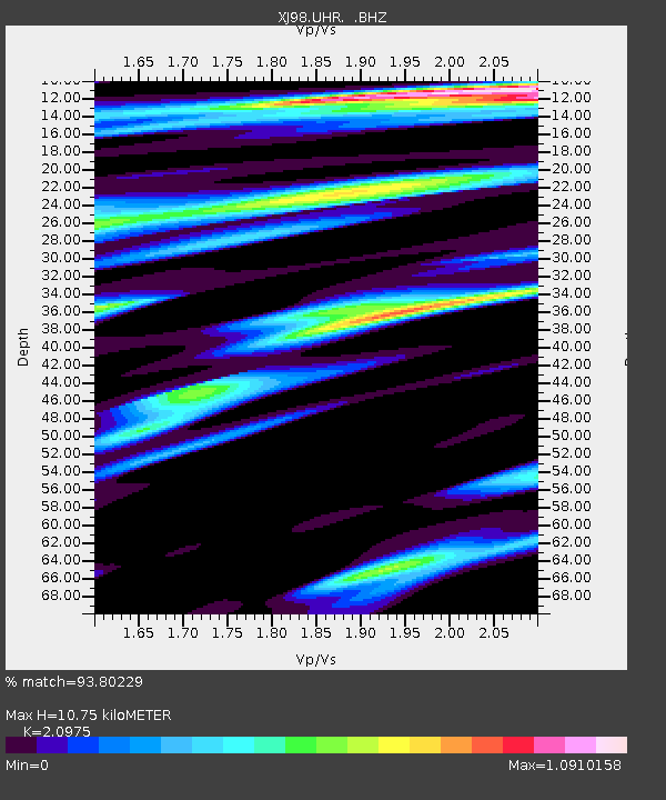
UHR Ust-Haryuzovo - Earthquake Result Viewer

Earthquake location: Santa Cruz Islands
Earthquake latitude/longitude: -12.9/166.7
Earthquake time(UTC): 1999/02/06 (037) 21:47:59 GMT
Earthquake Depth: 90 km
Earthquake Magnitude: 6.3 MB, 7.3 MS, 7.4 MW, 7.0 ME
Earthquake Catalog/Contributor: WHDF/NEIC
Network: XJ Side Edge of Kamchatka Subduction Zone
Station: UHR Ust-Haryuzovo
Lat/Lon: 57.09 N/156.77 E
Elevation: 118 m
Distance: 70.2 deg
Az: 354.257 deg
Baz: 169.7 deg
Ray Param: 0.05493724
Estimated Moho Depth: 10.75 km
Estimated Crust Vp/Vs: 2.10
Assumed Crust Vp: 6.438 km/s
Estimated Crust Vs: 3.069 km/s
Estimated Crust Poisson's Ratio: 0.35
Radial Match: 93.80229 %
Radial Bump: 400
Transverse Match: 89.8849 %
Transverse Bump: 400
SOD ConfigId: 4480
Insert Time: 2010-03-09 19:59:57.271 +0000
GWidth: 2.5
Max Bumps: 400
Tol: 0.001

Signal To Noise

ChannelStoNSTALTA
XJ:UHR: :BHZ:19990206T21:58:31.612029Z5.39969872.7180636E-65.033732E-7
XJ:UHR: :BHN:19990206T21:58:31.612029Z2.28243428.5932777E-73.7649622E-7
XJ:UHR: :BHE:19990206T21:58:31.612029Z1.34476886.134307E-74.561607E-7
Arrivals
Ps1.9 SECOND
PpPs5.0 SECOND
PsPs/PpSs6.9 SECOND