You are here: Home > Network List > GS - US Geological Survey Networks Stations List
> Station OK031 S. Brethren Rd., Cushing, OK, USA > Earthquake Result Viewer
OK031 S. Brethren Rd., Cushing, OK, USA - Earthquake Result Viewer
| Earthquake location: |
Greenland Sea |
| Earthquake latitude/longitude: |
74.6/8.4 |
| Earthquake time(UTC): |
2018/08/07 (219) 13:57:09 GMT |
| Earthquake Depth: |
10 km |
| Earthquake Magnitude: |
5.8 Mww |
| Earthquake Catalog/Contributor: |
NEIC PDE/us |
|
| Network: |
GS US Geological Survey Networks |
| Station: |
OK031 S. Brethren Rd., Cushing, OK, USA |
| Lat/Lon: |
35.95 N/96.84 W |
| Elevation: |
290 m |
|
| Distance: |
59.6 deg |
| Az: |
294.779 deg |
| Baz: |
17.362 deg |
| Ray Param: |
0.062102266 |
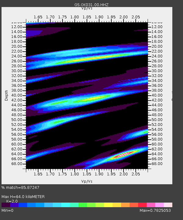
| Estimated Moho Depth: |
64.0 km |
| Estimated Crust Vp/Vs: |
2.00 |
| Assumed Crust Vp: |
6.426 km/s |
| Estimated Crust Vs: |
3.213 km/s |
| Estimated Crust Poisson's Ratio: |
0.33 |
|
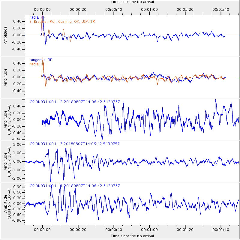
| Radial Match: |
85.87247 % |
| Radial Bump: |
400 |
| Transverse Match: |
58.514706 % |
| Transverse Bump: |
400 |
| SOD ConfigId: |
2778632 |
| Insert Time: |
2018-08-21 14:01:34.059 +0000 |
| GWidth: |
2.5 |
| Max Bumps: |
400 |
| Tol: |
0.001 |
|
Signal To Noise
| Channel | StoN | STA | LTA |
| GS:OK031:00:HHZ:20180807T14:06:42.513975Z | 12.335344 | 8.8859656E-7 | 7.203662E-8 |
| GS:OK031:00:HH1:20180807T14:06:42.513975Z | 3.0315015 | 3.1210195E-7 | 1.02952924E-7 |
| GS:OK031:00:HH2:20180807T14:06:42.513975Z | 2.7928011 | 3.2115335E-7 | 1.1499327E-7 |
| Arrivals |
| Ps | 10 SECOND |
| PpPs | 29 SECOND |
| PsPs/PpSs | 39 SECOND |


