You are here: Home > Network List > IW - Intermountain West Stations List
> Station FLWY Flagg Ranch, Wyoming, USA > Earthquake Result Viewer
FLWY Flagg Ranch, Wyoming, USA - Earthquake Result Viewer
| Earthquake location: |
Greenland Sea |
| Earthquake latitude/longitude: |
74.6/8.4 |
| Earthquake time(UTC): |
2018/08/07 (219) 13:57:09 GMT |
| Earthquake Depth: |
10 km |
| Earthquake Magnitude: |
5.8 Mww |
| Earthquake Catalog/Contributor: |
NEIC PDE/us |
|
| Network: |
IW Intermountain West |
| Station: |
FLWY Flagg Ranch, Wyoming, USA |
| Lat/Lon: |
44.08 N/110.70 W |
| Elevation: |
2078 m |
|
| Distance: |
54.9 deg |
| Az: |
309.69 deg |
| Baz: |
16.544 deg |
| Ray Param: |
0.065137744 |
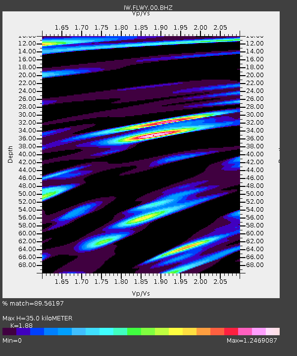
| Estimated Moho Depth: |
35.0 km |
| Estimated Crust Vp/Vs: |
1.88 |
| Assumed Crust Vp: |
6.35 km/s |
| Estimated Crust Vs: |
3.378 km/s |
| Estimated Crust Poisson's Ratio: |
0.30 |
|
| Radial Match: |
89.56197 % |
| Radial Bump: |
400 |
| Transverse Match: |
90.14795 % |
| Transverse Bump: |
400 |
| SOD ConfigId: |
2778632 |
| Insert Time: |
2018-08-21 14:02:57.909 +0000 |
| GWidth: |
2.5 |
| Max Bumps: |
400 |
| Tol: |
0.001 |
|

Signal To Noise
| Channel | StoN | STA | LTA |
| IW:FLWY:00:BHZ:20180807T14:06:09.739988Z | 8.5543165 | 3.5802657E-7 | 4.185332E-8 |
| IW:FLWY:00:BH1:20180807T14:06:09.739988Z | 4.731419 | 2.767353E-7 | 5.8488858E-8 |
| IW:FLWY:00:BH2:20180807T14:06:09.739988Z | 0.85024685 | 1.3849763E-7 | 1.6289107E-7 |
| Arrivals |
| Ps | 5.1 SECOND |
| PpPs | 15 SECOND |
| PsPs/PpSs | 20 SECOND |


