You are here: Home > Network List > IW - Intermountain West Stations List
> Station MOOW Moose Ponds, Wyoming, USA > Earthquake Result Viewer
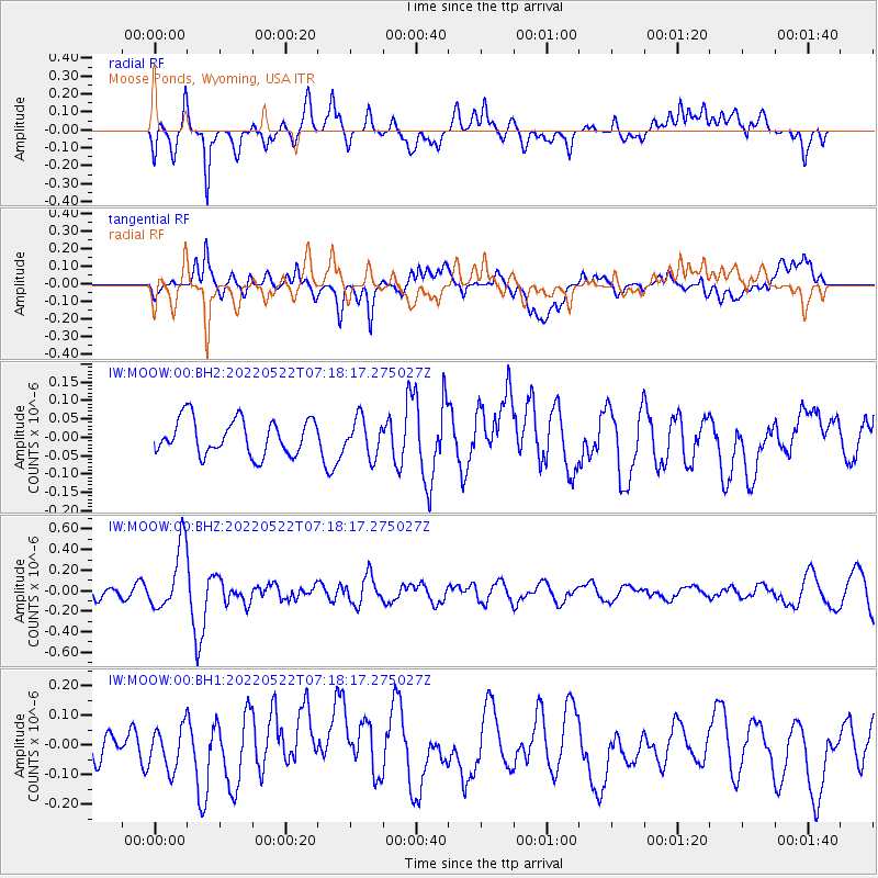
MOOW Moose Ponds, Wyoming, USA - Earthquake Result Viewer
*The percent match for this event was below the threshold and hence no stack was calculated.
| Earthquake location: |
South Of Fiji Islands |
| Earthquake latitude/longitude: |
-26.2/178.4 |
| Earthquake time(UTC): |
2022/05/22 (142) 07:06:27 GMT |
| Earthquake Depth: |
590 km |
| Earthquake Magnitude: |
6.3 mww |
| Earthquake Catalog/Contributor: |
NEIC PDE/us |
|
| Network: |
IW Intermountain West |
| Station: |
MOOW Moose Ponds, Wyoming, USA |
| Lat/Lon: |
43.75 N/110.74 W |
| Elevation: |
2128 m |
|
| Distance: |
95.1 deg |
| Az: |
43.425 deg |
| Baz: |
238.439 deg |
| Ray Param: |
$rayparam |
*The percent match for this event was below the threshold and hence was not used in the summary stack. |
|
| Radial Match: |
55.53239 % |
| Radial Bump: |
400 |
| Transverse Match: |
59.237576 % |
| Transverse Bump: |
400 |
| SOD ConfigId: |
27527651 |
| Insert Time: |
2022-06-05 07:22:18.337 +0000 |
| GWidth: |
2.5 |
| Max Bumps: |
400 |
| Tol: |
0.001 |
|
Signal To Noise
| Channel | StoN | STA | LTA |
| IW:MOOW:00:BHZ:20220522T07:18:17.275027Z | 3.403294 | 3.1841458E-7 | 9.35607E-8 |
| IW:MOOW:00:BH1:20220522T07:18:17.275027Z | 1.0692115 | 7.25617E-8 | 6.7864676E-8 |
| IW:MOOW:00:BH2:20220522T07:18:17.275027Z | 1.0419554 | 5.00872E-8 | 4.807039E-8 |
| Arrivals |
| Ps | |
| PpPs | |
| PsPs/PpSs | |


