You are here: Home > Network List > US - United States National Seismic Network Stations List
> Station HAWA Hanford, Washington, USA > Earthquake Result Viewer
HAWA Hanford, Washington, USA - Earthquake Result Viewer
*The percent match for this event was below the threshold and hence no stack was calculated.
| Earthquake location: |
South Of Fiji Islands |
| Earthquake latitude/longitude: |
-26.2/178.4 |
| Earthquake time(UTC): |
2022/05/22 (142) 07:06:27 GMT |
| Earthquake Depth: |
590 km |
| Earthquake Magnitude: |
6.3 mww |
| Earthquake Catalog/Contributor: |
NEIC PDE/us |
|
| Network: |
US United States National Seismic Network |
| Station: |
HAWA Hanford, Washington, USA |
| Lat/Lon: |
46.39 N/119.53 W |
| Elevation: |
364 m |
|
| Distance: |
91.5 deg |
| Az: |
37.717 deg |
| Baz: |
232.56 deg |
| Ray Param: |
$rayparam |
*The percent match for this event was below the threshold and hence was not used in the summary stack. |
|
| Radial Match: |
72.98325 % |
| Radial Bump: |
400 |
| Transverse Match: |
60.857204 % |
| Transverse Bump: |
400 |
| SOD ConfigId: |
27527651 |
| Insert Time: |
2022-06-05 07:28:12.424 +0000 |
| GWidth: |
2.5 |
| Max Bumps: |
400 |
| Tol: |
0.001 |
|
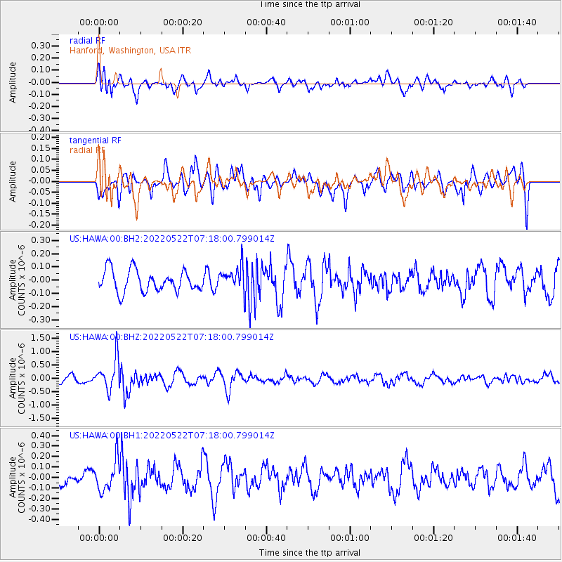
Signal To Noise
| Channel | StoN | STA | LTA |
| US:HAWA:00:BHZ:20220522T07:18:00.799014Z | 5.3214135 | 5.9772276E-7 | 1.1232407E-7 |
| US:HAWA:00:BH1:20220522T07:18:00.799014Z | 2.150091 | 1.511533E-7 | 7.0300885E-8 |
| US:HAWA:00:BH2:20220522T07:18:00.799014Z | 1.1277659 | 9.128622E-8 | 8.09443E-8 |
| Arrivals |
| Ps | |
| PpPs | |
| PsPs/PpSs | |


