You are here: Home > Network List > UW - Pacific Northwest Regional Seismic Network Stations List
> Station HOOD Mt Hood Meadows, OR CREST BB SMO > Earthquake Result Viewer
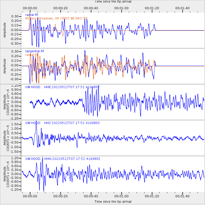
HOOD Mt Hood Meadows, OR CREST BB SMO - Earthquake Result Viewer
*The percent match for this event was below the threshold and hence no stack was calculated.
| Earthquake location: |
South Of Fiji Islands |
| Earthquake latitude/longitude: |
-26.2/178.4 |
| Earthquake time(UTC): |
2022/05/22 (142) 07:06:27 GMT |
| Earthquake Depth: |
590 km |
| Earthquake Magnitude: |
6.3 mww |
| Earthquake Catalog/Contributor: |
NEIC PDE/us |
|
| Network: |
UW Pacific Northwest Regional Seismic Network |
| Station: |
HOOD Mt Hood Meadows, OR CREST BB SMO |
| Lat/Lon: |
45.32 N/121.65 W |
| Elevation: |
1520 m |
|
| Distance: |
89.7 deg |
| Az: |
37.642 deg |
| Baz: |
231.044 deg |
| Ray Param: |
$rayparam |
*The percent match for this event was below the threshold and hence was not used in the summary stack. |
|
| Radial Match: |
67.01843 % |
| Radial Bump: |
400 |
| Transverse Match: |
66.26496 % |
| Transverse Bump: |
400 |
| SOD ConfigId: |
27527651 |
| Insert Time: |
2022-06-05 07:29:38.390 +0000 |
| GWidth: |
2.5 |
| Max Bumps: |
400 |
| Tol: |
0.001 |
|
Signal To Noise
| Channel | StoN | STA | LTA |
| UW:HOOD: :HHZ:20220522T07:17:52.419986Z | 5.1962705 | 6.131837E-7 | 1.1800458E-7 |
| UW:HOOD: :HHN:20220522T07:17:52.419986Z | 2.4545913 | 2.8823774E-7 | 1.17428E-7 |
| UW:HOOD: :HHE:20220522T07:17:52.419986Z | 1.072247 | 1.5000109E-7 | 1.3989415E-7 |
| Arrivals |
| Ps | |
| PpPs | |
| PsPs/PpSs | |


