You are here: Home > Network List > TX - Texas Seismological Network Stations List
> Station SGCY Sterling City > Earthquake Result Viewer
SGCY Sterling City - Earthquake Result Viewer
| Earthquake location: |
Greenland Sea |
| Earthquake latitude/longitude: |
74.6/8.4 |
| Earthquake time(UTC): |
2018/08/07 (219) 13:57:09 GMT |
| Earthquake Depth: |
10 km |
| Earthquake Magnitude: |
5.8 Mww |
| Earthquake Catalog/Contributor: |
NEIC PDE/us |
|
| Network: |
TX Texas Seismological Network |
| Station: |
SGCY Sterling City |
| Lat/Lon: |
31.91 N/101.13 W |
| Elevation: |
776 m |
|
| Distance: |
64.5 deg |
| Az: |
297.328 deg |
| Baz: |
16.175 deg |
| Ray Param: |
0.058912516 |
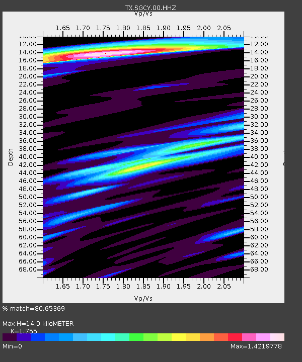
| Estimated Moho Depth: |
14.0 km |
| Estimated Crust Vp/Vs: |
1.75 |
| Assumed Crust Vp: |
6.38 km/s |
| Estimated Crust Vs: |
3.636 km/s |
| Estimated Crust Poisson's Ratio: |
0.26 |
|
| Radial Match: |
80.65369 % |
| Radial Bump: |
400 |
| Transverse Match: |
68.675125 % |
| Transverse Bump: |
400 |
| SOD ConfigId: |
2778632 |
| Insert Time: |
2018-08-21 14:05:04.148 +0000 |
| GWidth: |
2.5 |
| Max Bumps: |
400 |
| Tol: |
0.001 |
|

Signal To Noise
| Channel | StoN | STA | LTA |
| TX:SGCY:00:HHZ:20180807T14:07:15.265012Z | 3.1048298 | 4.35208E-7 | 1.4017128E-7 |
| TX:SGCY:00:HH1:20180807T14:07:15.265012Z | 2.7392776 | 1.0898925E-7 | 3.9787587E-8 |
| TX:SGCY:00:HH2:20180807T14:07:15.265012Z | 1.7878007 | 2.3315164E-7 | 1.3041254E-7 |
| Arrivals |
| Ps | 1.7 SECOND |
| PpPs | 5.8 SECOND |
| PsPs/PpSs | 7.5 SECOND |


