You are here: Home > Network List > AK - Alaska Regional Network Stations List
> Station B20K Meade River, AK, USA > Earthquake Result Viewer
B20K Meade River, AK, USA - Earthquake Result Viewer
| Earthquake location: |
Off East Coast Of Honshu, Japan |
| Earthquake latitude/longitude: |
33.2/141.5 |
| Earthquake time(UTC): |
2022/05/22 (142) 15:17:32 GMT |
| Earthquake Depth: |
17 km |
| Earthquake Magnitude: |
6.0 mww |
| Earthquake Catalog/Contributor: |
NEIC PDE/us |
|
| Network: |
AK Alaska Regional Network |
| Station: |
B20K Meade River, AK, USA |
| Lat/Lon: |
70.01 N/157.16 W |
| Elevation: |
75 m |
|
| Distance: |
49.4 deg |
| Az: |
23.419 deg |
| Baz: |
255.579 deg |
| Ray Param: |
0.06870364 |
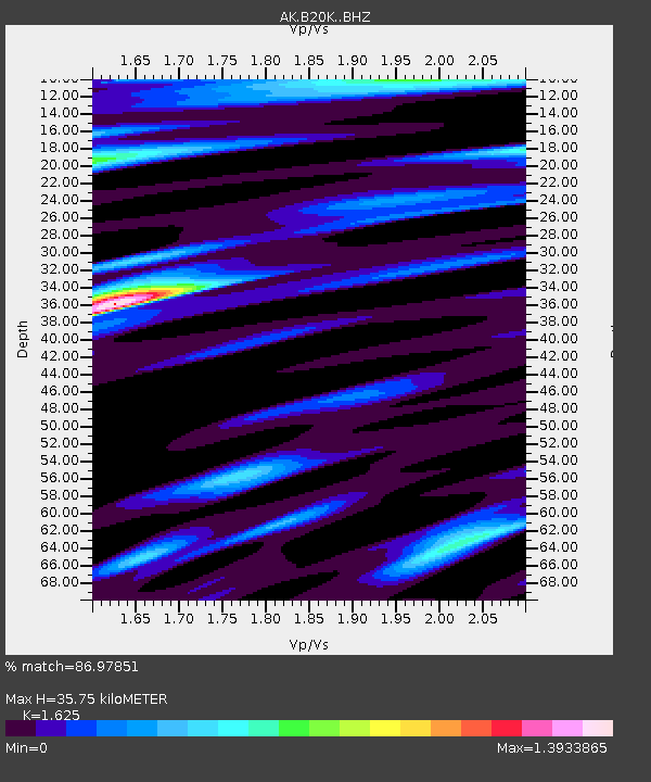
| Estimated Moho Depth: |
35.75 km |
| Estimated Crust Vp/Vs: |
1.62 |
| Assumed Crust Vp: |
6.048 km/s |
| Estimated Crust Vs: |
3.722 km/s |
| Estimated Crust Poisson's Ratio: |
0.20 |
|
| Radial Match: |
86.97851 % |
| Radial Bump: |
400 |
| Transverse Match: |
69.64185 % |
| Transverse Bump: |
400 |
| SOD ConfigId: |
27527651 |
| Insert Time: |
2022-06-05 15:19:51.513 +0000 |
| GWidth: |
2.5 |
| Max Bumps: |
400 |
| Tol: |
0.001 |
|

Signal To Noise
| Channel | StoN | STA | LTA |
| AK:B20K: :BHZ:20220522T15:25:50.359988Z | 3.44441 | 3.3337358E-7 | 9.6786835E-8 |
| AK:B20K: :BHN:20220522T15:25:50.359988Z | 1.425785 | 1.5641767E-7 | 1.0970635E-7 |
| AK:B20K: :BHE:20220522T15:25:50.359988Z | 1.541987 | 1.4692081E-7 | 9.5280186E-8 |
| Arrivals |
| Ps | 3.9 SECOND |
| PpPs | 15 SECOND |
| PsPs/PpSs | 19 SECOND |


