You are here: Home > Network List > AK - Alaska Regional Network Stations List
> Station F21K Alatna River, AK, USA > Earthquake Result Viewer
F21K Alatna River, AK, USA - Earthquake Result Viewer
| Earthquake location: |
Off East Coast Of Honshu, Japan |
| Earthquake latitude/longitude: |
33.2/141.5 |
| Earthquake time(UTC): |
2022/05/22 (142) 15:17:32 GMT |
| Earthquake Depth: |
17 km |
| Earthquake Magnitude: |
6.0 mww |
| Earthquake Catalog/Contributor: |
NEIC PDE/us |
|
| Network: |
AK Alaska Regional Network |
| Station: |
F21K Alatna River, AK, USA |
| Lat/Lon: |
67.22 N/153.48 W |
| Elevation: |
597 m |
|
| Distance: |
50.2 deg |
| Az: |
27.359 deg |
| Baz: |
261.544 deg |
| Ray Param: |
0.068198375 |
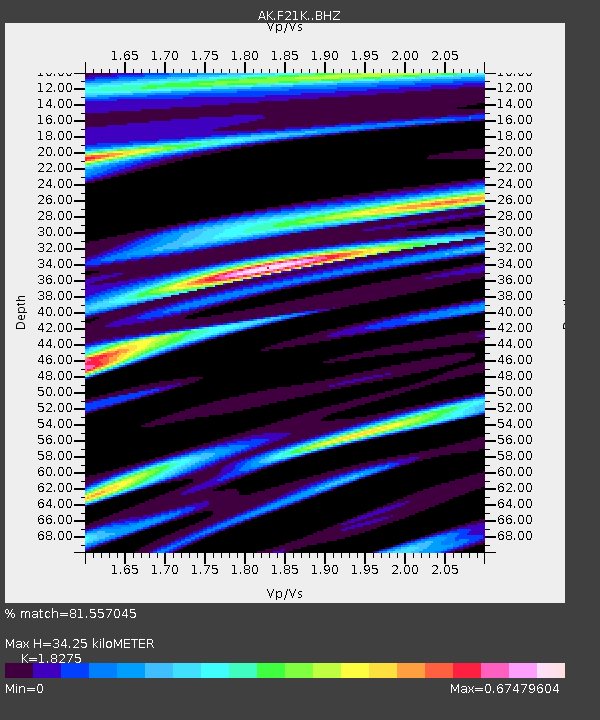
| Estimated Moho Depth: |
34.25 km |
| Estimated Crust Vp/Vs: |
1.83 |
| Assumed Crust Vp: |
6.455 km/s |
| Estimated Crust Vs: |
3.532 km/s |
| Estimated Crust Poisson's Ratio: |
0.29 |
|
| Radial Match: |
81.557045 % |
| Radial Bump: |
400 |
| Transverse Match: |
66.64754 % |
| Transverse Bump: |
400 |
| SOD ConfigId: |
27527651 |
| Insert Time: |
2022-06-05 15:20:31.640 +0000 |
| GWidth: |
2.5 |
| Max Bumps: |
400 |
| Tol: |
0.001 |
|

Signal To Noise
| Channel | StoN | STA | LTA |
| AK:F21K: :BHZ:20220522T15:25:56.179995Z | 1.7881038 | 1.04175164E-7 | 5.826013E-8 |
| AK:F21K: :BHN:20220522T15:25:56.179995Z | 1.6647543 | 7.8010366E-8 | 4.6859988E-8 |
| AK:F21K: :BHE:20220522T15:25:56.179995Z | 0.9298788 | 5.9198115E-8 | 6.3662185E-8 |
| Arrivals |
| Ps | 4.6 SECOND |
| PpPs | 14 SECOND |
| PsPs/PpSs | 19 SECOND |


