You are here: Home > Network List > AV - Alaska Volcano Observatory Stations List
> Station MAPS Pakushin Southeast, Makushin Volcano, Alaska > Earthquake Result Viewer
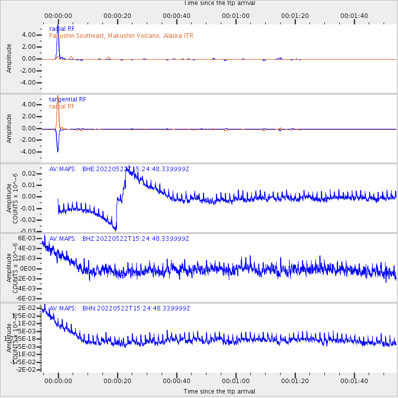
MAPS Pakushin Southeast, Makushin Volcano, Alaska - Earthquake Result Viewer
| Earthquake location: |
Off East Coast Of Honshu, Japan |
| Earthquake latitude/longitude: |
33.2/141.5 |
| Earthquake time(UTC): |
2022/05/22 (142) 15:17:32 GMT |
| Earthquake Depth: |
17 km |
| Earthquake Magnitude: |
6.0 mww |
| Earthquake Catalog/Contributor: |
NEIC PDE/us |
|
| Network: |
AV Alaska Volcano Observatory |
| Station: |
MAPS Pakushin Southeast, Makushin Volcano, Alaska |
| Lat/Lon: |
53.81 N/166.94 W |
| Elevation: |
333 m |
|
| Distance: |
41.6 deg |
| Az: |
44.453 deg |
| Baz: |
261.73 deg |
| Ray Param: |
0.07368071 |
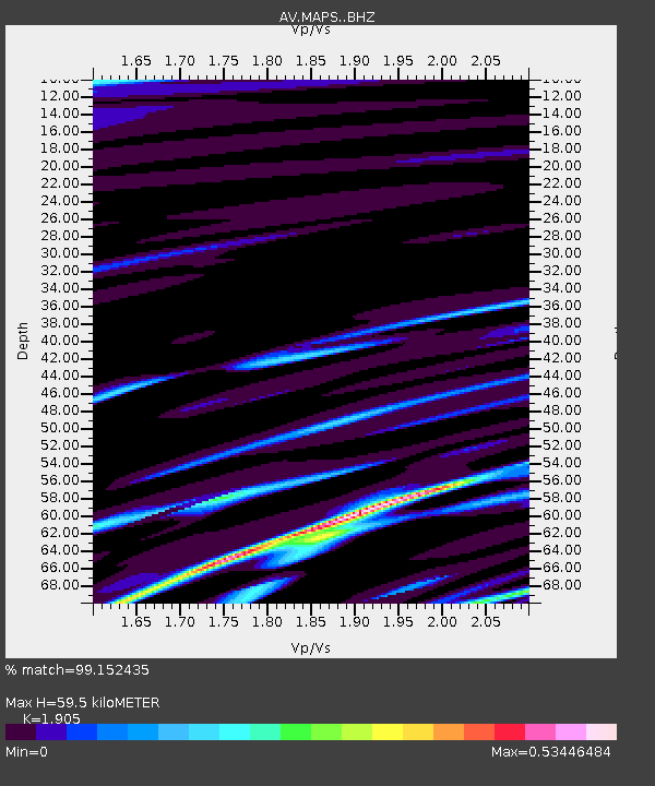
| Estimated Moho Depth: |
59.5 km |
| Estimated Crust Vp/Vs: |
1.90 |
| Assumed Crust Vp: |
3.943 km/s |
| Estimated Crust Vs: |
2.07 km/s |
| Estimated Crust Poisson's Ratio: |
0.31 |
|
| Radial Match: |
99.152435 % |
| Radial Bump: |
76 |
| Transverse Match: |
99.01727 % |
| Transverse Bump: |
55 |
| SOD ConfigId: |
27527651 |
| Insert Time: |
2022-06-05 15:23:25.989 +0000 |
| GWidth: |
2.5 |
| Max Bumps: |
400 |
| Tol: |
0.001 |
|
Signal To Noise
| Channel | StoN | STA | LTA |
| AV:MAPS: :BHZ:20220522T15:24:48.339999Z | 1.5487543 | 4.7892876E-9 | 3.092348E-9 |
| AV:MAPS: :BHN:20220522T15:24:48.339999Z | 1.5252086 | 1.6415436E-8 | 1.0762748E-8 |
| AV:MAPS: :BHE:20220522T15:24:48.339999Z | 1.4995713 | 1.7918893E-8 | 1.1949344E-8 |
| Arrivals |
| Ps | 14 SECOND |
| PpPs | 43 SECOND |
| PsPs/PpSs | 57 SECOND |


