You are here: Home > Network List > CC - Cascade Chain Volcano Monitoring Stations List
> Station SWF2 Southwest Flank moved down hill, Mt. St. Helens, WA > Earthquake Result Viewer
SWF2 Southwest Flank moved down hill, Mt. St. Helens, WA - Earthquake Result Viewer
| Earthquake location: |
Off East Coast Of Honshu, Japan |
| Earthquake latitude/longitude: |
33.2/141.5 |
| Earthquake time(UTC): |
2022/05/22 (142) 15:17:32 GMT |
| Earthquake Depth: |
17 km |
| Earthquake Magnitude: |
6.0 mww |
| Earthquake Catalog/Contributor: |
NEIC PDE/us |
|
| Network: |
CC Cascade Chain Volcano Monitoring |
| Station: |
SWF2 Southwest Flank moved down hill, Mt. St. Helens, WA |
| Lat/Lon: |
46.18 N/122.22 W |
| Elevation: |
1548 m |
|
| Distance: |
70.8 deg |
| Az: |
46.977 deg |
| Baz: |
298.144 deg |
| Ray Param: |
0.05470892 |
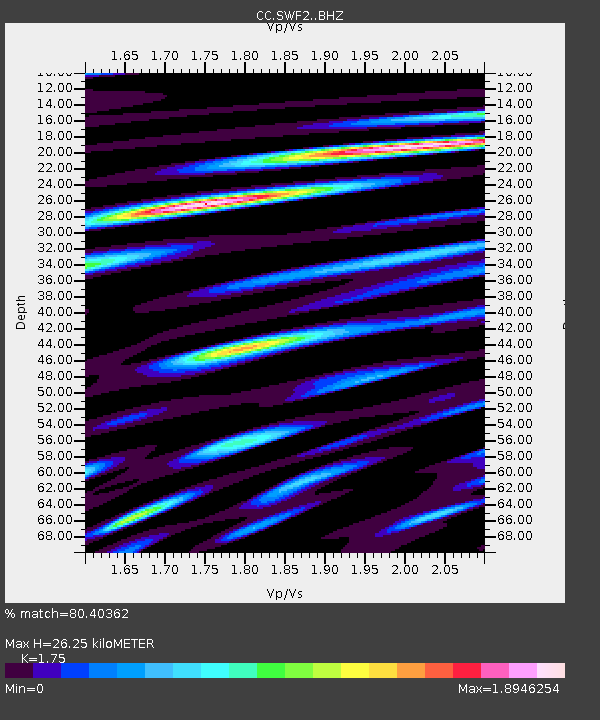
| Estimated Moho Depth: |
26.25 km |
| Estimated Crust Vp/Vs: |
1.75 |
| Assumed Crust Vp: |
6.566 km/s |
| Estimated Crust Vs: |
3.752 km/s |
| Estimated Crust Poisson's Ratio: |
0.26 |
|
| Radial Match: |
80.40362 % |
| Radial Bump: |
400 |
| Transverse Match: |
69.42314 % |
| Transverse Bump: |
400 |
| SOD ConfigId: |
27527651 |
| Insert Time: |
2022-06-05 15:26:22.642 +0000 |
| GWidth: |
2.5 |
| Max Bumps: |
400 |
| Tol: |
0.001 |
|

Signal To Noise
| Channel | StoN | STA | LTA |
| CC:SWF2: :BHZ:20220522T15:28:16.82001Z | 1.7935246 | 2.0293896E-7 | 1.1315092E-7 |
| CC:SWF2: :BHN:20220522T15:28:16.82001Z | 1.1006811 | 1.7818847E-7 | 1.6188929E-7 |
| CC:SWF2: :BHE:20220522T15:28:16.82001Z | 0.90353596 | 1.8296892E-7 | 2.025032E-7 |
| Arrivals |
| Ps | 3.1 SECOND |
| PpPs | 11 SECOND |
| PsPs/PpSs | 14 SECOND |


