You are here: Home > Network List > MM - Myanmar National Seismic Network Stations List
> Station NGU Ngaung U, Myanmar > Earthquake Result Viewer
NGU Ngaung U, Myanmar - Earthquake Result Viewer
| Earthquake location: |
Off East Coast Of Honshu, Japan |
| Earthquake latitude/longitude: |
33.2/141.5 |
| Earthquake time(UTC): |
2022/05/22 (142) 15:17:32 GMT |
| Earthquake Depth: |
17 km |
| Earthquake Magnitude: |
6.0 mww |
| Earthquake Catalog/Contributor: |
NEIC PDE/us |
|
| Network: |
MM Myanmar National Seismic Network |
| Station: |
NGU Ngaung U, Myanmar |
| Lat/Lon: |
21.21 N/94.92 E |
| Elevation: |
70 m |
|
| Distance: |
42.8 deg |
| Az: |
265.875 deg |
| Baz: |
63.612 deg |
| Ray Param: |
0.07296451 |
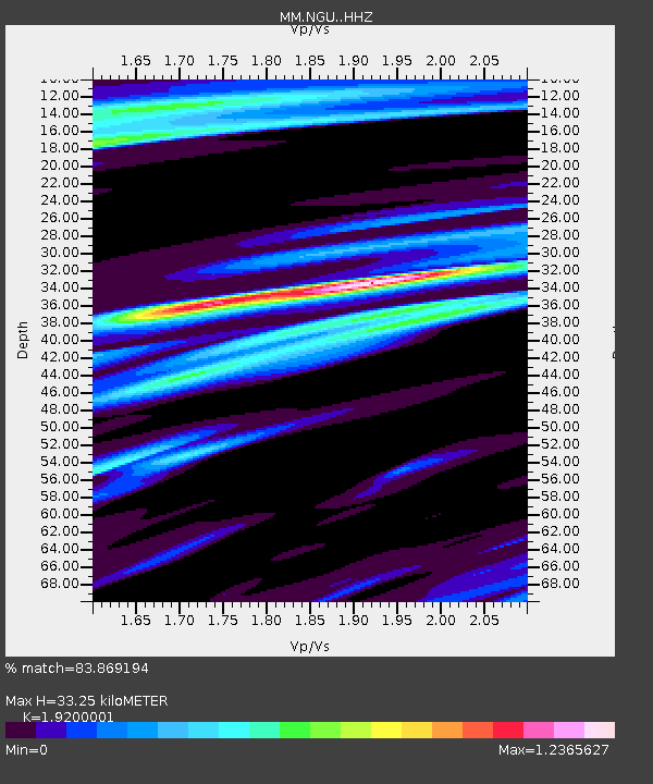
| Estimated Moho Depth: |
33.25 km |
| Estimated Crust Vp/Vs: |
1.92 |
| Assumed Crust Vp: |
6.036 km/s |
| Estimated Crust Vs: |
3.144 km/s |
| Estimated Crust Poisson's Ratio: |
0.31 |
|
| Radial Match: |
83.869194 % |
| Radial Bump: |
400 |
| Transverse Match: |
70.70858 % |
| Transverse Bump: |
400 |
| SOD ConfigId: |
27527651 |
| Insert Time: |
2022-06-05 15:35:09.472 +0000 |
| GWidth: |
2.5 |
| Max Bumps: |
400 |
| Tol: |
0.001 |
|

Signal To Noise
| Channel | StoN | STA | LTA |
| MM:NGU: :HHZ:20220522T15:24:57.919985Z | 17.97137 | 3.0087986E-6 | 1.6742176E-7 |
| MM:NGU: :HHN:20220522T15:24:57.919985Z | 1.944598 | 4.5766066E-7 | 2.3534976E-7 |
| MM:NGU: :HHE:20220522T15:24:57.919985Z | 3.2116492 | 6.508965E-7 | 2.0266737E-7 |
| Arrivals |
| Ps | 5.3 SECOND |
| PpPs | 15 SECOND |
| PsPs/PpSs | 21 SECOND |


