You are here: Home > Network List > IU - Global Seismograph Network (GSN - IRIS/USGS) Stations List
> Station GNI Garni, Armenia > Earthquake Result Viewer
GNI Garni, Armenia - Earthquake Result Viewer

| Earthquake location: |
Kyushu, Japan |
| Earthquake latitude/longitude: |
31.1/130.0 |
| Earthquake time(UTC): |
2009/09/03 (246) 13:26:18 GMT |
| Earthquake Depth: |
166 km |
| Earthquake Magnitude: |
5.9 MB, 6.2 MW, 6.2 MW |
| Earthquake Catalog/Contributor: |
WHDF/NEIC |
|
| Network: |
IU Global Seismograph Network (GSN - IRIS/USGS) |
| Station: |
GNI Garni, Armenia |
| Lat/Lon: |
40.15 N/44.74 E |
| Elevation: |
1609 m |
|
| Distance: |
67.4 deg |
| Az: |
304.152 deg |
| Baz: |
67.774 deg |
| Ray Param: |
0.056529433 |
| Estimated Moho Depth: |
69.75 km |
| Estimated Crust Vp/Vs: |
1.82 |
| Assumed Crust Vp: |
6.291 km/s |
| Estimated Crust Vs: |
3.466 km/s |
| Estimated Crust Poisson's Ratio: |
0.28 |
|
| Radial Match: |
83.275505 % |
| Radial Bump: |
400 |
| Transverse Match: |
80.339195 % |
| Transverse Bump: |
400 |
| SOD ConfigId: |
1 |
| Insert Time: |
2010-02-19 00:07:45.007 +0000 |
| GWidth: |
2.5 |
| Max Bumps: |
400 |
| Tol: |
0.001 |
|
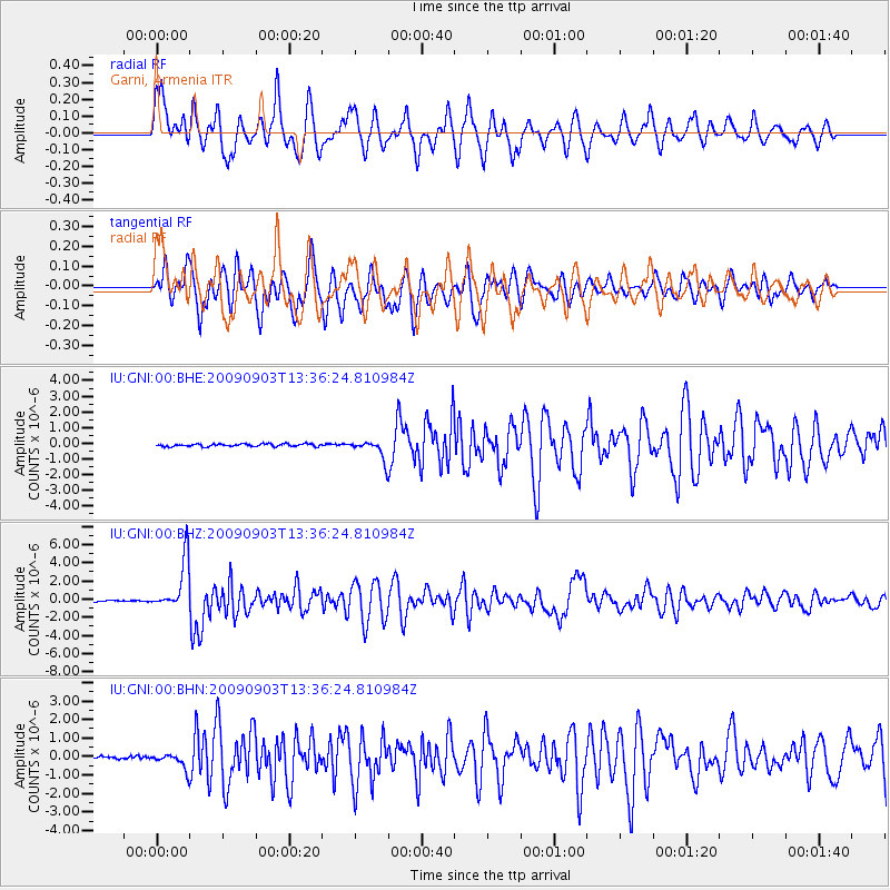
Signal To Noise
| Channel | StoN | STA | LTA |
| IU:GNI:00:BHZ:20090903T13:36:24.810984Z | 42.542854 | 2.794432E-6 | 6.568511E-8 |
| IU:GNI:00:BHN:20090903T13:36:24.810984Z | 5.4274616 | 4.224064E-7 | 7.7827615E-8 |
| IU:GNI:00:BHE:20090903T13:36:24.810984Z | 7.0805807 | 6.0116923E-7 | 8.4903945E-8 |
| Arrivals |
| Ps | 9.4 SECOND |
| PpPs | 30 SECOND |
| PsPs/PpSs | 39 SECOND |


