You are here: Home > Network List > US - United States National Seismic Network Stations List
> Station HAWA Hanford, Washington, USA > Earthquake Result Viewer
HAWA Hanford, Washington, USA - Earthquake Result Viewer
*The percent match for this event was below the threshold and hence no stack was calculated.
| Earthquake location: |
Peru-Bolivia Border Region |
| Earthquake latitude/longitude: |
-17.5/-69.5 |
| Earthquake time(UTC): |
2022/05/24 (144) 12:57:58 GMT |
| Earthquake Depth: |
148 km |
| Earthquake Magnitude: |
5.4 mww |
| Earthquake Catalog/Contributor: |
NEIC PDE/us |
|
| Network: |
US United States National Seismic Network |
| Station: |
HAWA Hanford, Washington, USA |
| Lat/Lon: |
46.39 N/119.53 W |
| Elevation: |
364 m |
|
| Distance: |
78.0 deg |
| Az: |
327.179 deg |
| Baz: |
131.649 deg |
| Ray Param: |
$rayparam |
*The percent match for this event was below the threshold and hence was not used in the summary stack. |
|
| Radial Match: |
54.572826 % |
| Radial Bump: |
400 |
| Transverse Match: |
54.443848 % |
| Transverse Bump: |
400 |
| SOD ConfigId: |
27527651 |
| Insert Time: |
2022-06-07 13:19:48.551 +0000 |
| GWidth: |
2.5 |
| Max Bumps: |
400 |
| Tol: |
0.001 |
|
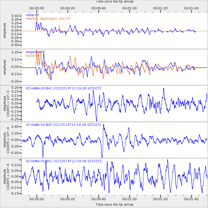
Signal To Noise
| Channel | StoN | STA | LTA |
| US:HAWA:00:BHZ:20220524T13:09:08.925025Z | 3.9564638 | 1.6782461E-7 | 4.241783E-8 |
| US:HAWA:00:BH1:20220524T13:09:08.925025Z | 1.030428 | 5.3494276E-8 | 5.1914615E-8 |
| US:HAWA:00:BH2:20220524T13:09:08.925025Z | 1.5727845 | 6.8838446E-8 | 4.3768516E-8 |
| Arrivals |
| Ps | |
| PpPs | |
| PsPs/PpSs | |


