You are here: Home > Network List > XM99 - Rio Grande Seismic Transect Stations List
> Station NM16 NewMexico16 > Earthquake Result Viewer
NM16 NewMexico16 - Earthquake Result Viewer
| Earthquake location: |
Southeast Of Honshu, Japan |
| Earthquake latitude/longitude: |
34.0/139.3 |
| Earthquake time(UTC): |
2000/07/30 (212) 12:48:55 GMT |
| Earthquake Depth: |
10 km |
| Earthquake Magnitude: |
5.5 MB |
| Earthquake Catalog/Contributor: |
WHDF/NEIC |
|
| Network: |
XM Rio Grande Seismic Transect |
| Station: |
NM16 NewMexico16 |
| Lat/Lon: |
33.17 N/105.13 W |
| Elevation: |
1625 m |
|
| Distance: |
89.9 deg |
| Az: |
49.142 deg |
| Baz: |
311.444 deg |
| Ray Param: |
0.04171081 |
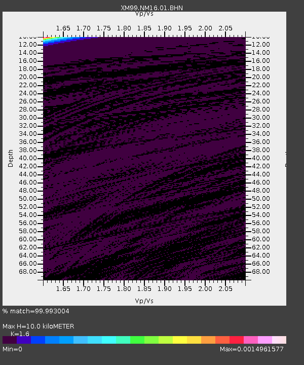
| Estimated Moho Depth: |
10.0 km |
| Estimated Crust Vp/Vs: |
1.60 |
| Assumed Crust Vp: |
6.232 km/s |
| Estimated Crust Vs: |
3.895 km/s |
| Estimated Crust Poisson's Ratio: |
0.18 |
|
| Radial Match: |
99.993004 % |
| Radial Bump: |
2 |
| Transverse Match: |
99.89421 % |
| Transverse Bump: |
2 |
| SOD ConfigId: |
16820 |
| Insert Time: |
2010-02-26 17:25:56.006 +0000 |
| GWidth: |
2.5 |
| Max Bumps: |
400 |
| Tol: |
0.001 |
|
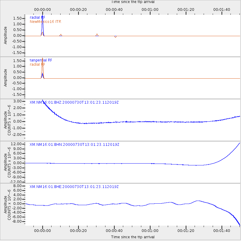
Signal To Noise
| Channel | StoN | STA | LTA |
| XM:NM16:01:BHN:20000730T13:01:23.112019Z | 0.9076262 | 9.729891E-7 | 1.0720153E-6 |
| XM:NM16:01:BHE:20000730T13:01:23.112019Z | 1.6836842 | 1.0723462E-6 | 6.369046E-7 |
| XM:NM16:01:BHZ:20000730T13:01:23.112019Z | 0.90986526 | 9.046966E-7 | 9.943193E-7 |
| Arrivals |
| Ps | 1.0 SECOND |
| PpPs | 4.1 SECOND |
| PsPs/PpSs | 5.1 SECOND |


