You are here: Home > Network List > AE - Arizona Broadband Seismic Network Stations List
> Station BABIT Valle/Cataract Creek > Earthquake Result Viewer
BABIT Valle/Cataract Creek - Earthquake Result Viewer
| Earthquake location: |
Southern Peru |
| Earthquake latitude/longitude: |
-15.0/-70.4 |
| Earthquake time(UTC): |
2022/05/26 (146) 12:02:19 GMT |
| Earthquake Depth: |
212 km |
| Earthquake Magnitude: |
7.2 Mi |
| Earthquake Catalog/Contributor: |
NEIC PDE/at |
|
| Network: |
AE Arizona Broadband Seismic Network |
| Station: |
BABIT Valle/Cataract Creek |
| Lat/Lon: |
35.75 N/112.42 W |
| Elevation: |
1694 m |
|
| Distance: |
64.3 deg |
| Az: |
322.802 deg |
| Baz: |
134.094 deg |
| Ray Param: |
0.05840697 |
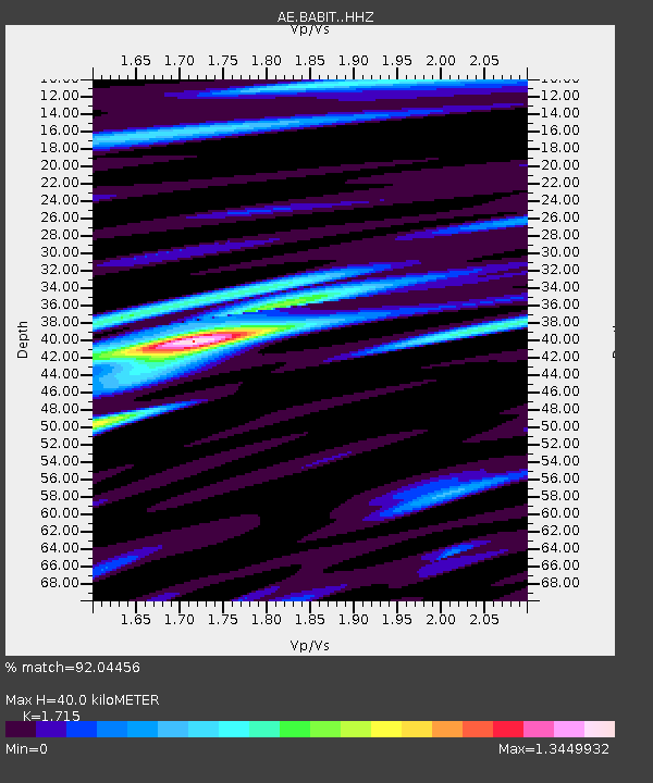
| Estimated Moho Depth: |
40.0 km |
| Estimated Crust Vp/Vs: |
1.72 |
| Assumed Crust Vp: |
6.276 km/s |
| Estimated Crust Vs: |
3.659 km/s |
| Estimated Crust Poisson's Ratio: |
0.24 |
|
| Radial Match: |
92.04456 % |
| Radial Bump: |
400 |
| Transverse Match: |
72.38202 % |
| Transverse Bump: |
400 |
| SOD ConfigId: |
27527651 |
| Insert Time: |
2022-06-09 12:04:16.491 +0000 |
| GWidth: |
2.5 |
| Max Bumps: |
400 |
| Tol: |
0.001 |
|

Signal To Noise
| Channel | StoN | STA | LTA |
| AE:BABIT: :HHZ:20220526T12:12:00.52002Z | 8.710789 | 7.057776E-7 | 8.102339E-8 |
| AE:BABIT: :HHN:20220526T12:12:00.52002Z | 3.9624045 | 1.9320088E-7 | 4.8758494E-8 |
| AE:BABIT: :HHE:20220526T12:12:00.52002Z | 2.2234042 | 2.4957154E-7 | 1.1224749E-7 |
| Arrivals |
| Ps | 4.7 SECOND |
| PpPs | 17 SECOND |
| PsPs/PpSs | 21 SECOND |


