You are here: Home > Network List > AE - Arizona Broadband Seismic Network Stations List
> Station X16A Lo Mia Camp, Pine, AZ, USA > Earthquake Result Viewer
X16A Lo Mia Camp, Pine, AZ, USA - Earthquake Result Viewer
| Earthquake location: |
Southern Peru |
| Earthquake latitude/longitude: |
-15.0/-70.4 |
| Earthquake time(UTC): |
2022/05/26 (146) 12:02:19 GMT |
| Earthquake Depth: |
212 km |
| Earthquake Magnitude: |
7.2 Mi |
| Earthquake Catalog/Contributor: |
NEIC PDE/at |
|
| Network: |
AE Arizona Broadband Seismic Network |
| Station: |
X16A Lo Mia Camp, Pine, AZ, USA |
| Lat/Lon: |
34.42 N/111.44 W |
| Elevation: |
1759 m |
|
| Distance: |
62.8 deg |
| Az: |
322.37 deg |
| Baz: |
134.463 deg |
| Ray Param: |
0.059371904 |
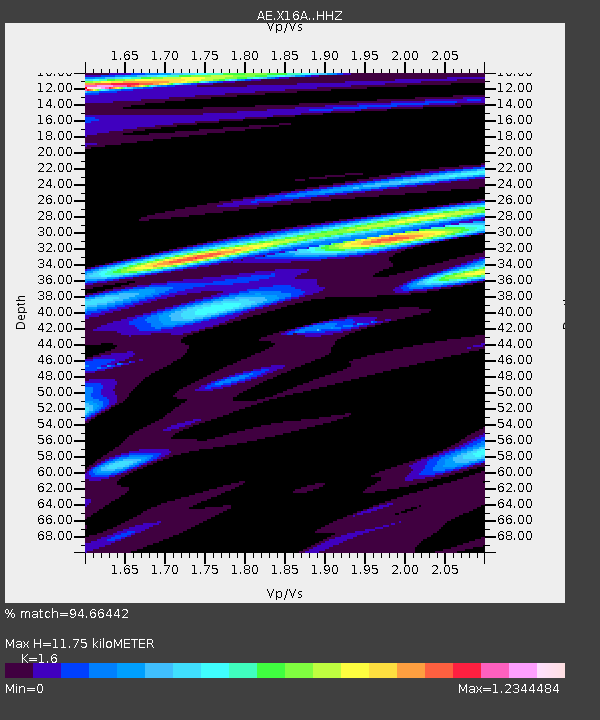
| Estimated Moho Depth: |
11.75 km |
| Estimated Crust Vp/Vs: |
1.60 |
| Assumed Crust Vp: |
6.207 km/s |
| Estimated Crust Vs: |
3.879 km/s |
| Estimated Crust Poisson's Ratio: |
0.18 |
|
| Radial Match: |
94.66442 % |
| Radial Bump: |
400 |
| Transverse Match: |
81.618256 % |
| Transverse Bump: |
400 |
| SOD ConfigId: |
27527651 |
| Insert Time: |
2022-06-09 12:04:29.772 +0000 |
| GWidth: |
2.5 |
| Max Bumps: |
400 |
| Tol: |
0.001 |
|

Signal To Noise
| Channel | StoN | STA | LTA |
| AE:X16A: :HHZ:20220526T12:11:50.719971Z | 10.264595 | 9.14633E-7 | 8.910561E-8 |
| AE:X16A: :HHN:20220526T12:11:50.719971Z | 5.268247 | 2.9931863E-7 | 5.6815598E-8 |
| AE:X16A: :HHE:20220526T12:11:50.719971Z | 4.2933116 | 3.5049592E-7 | 8.1637666E-8 |
| Arrivals |
| Ps | 1.2 SECOND |
| PpPs | 4.7 SECOND |
| PsPs/PpSs | 5.9 SECOND |


