You are here: Home > Network List > C0 - Colorado Geological Survey Seismic Network Stations List
> Station CHIL CSU-CHILL Radar > Earthquake Result Viewer
CHIL CSU-CHILL Radar - Earthquake Result Viewer
| Earthquake location: |
Southern Peru |
| Earthquake latitude/longitude: |
-15.0/-70.4 |
| Earthquake time(UTC): |
2022/05/26 (146) 12:02:19 GMT |
| Earthquake Depth: |
212 km |
| Earthquake Magnitude: |
7.2 Mi |
| Earthquake Catalog/Contributor: |
NEIC PDE/at |
|
| Network: |
C0 Colorado Geological Survey Seismic Network |
| Station: |
CHIL CSU-CHILL Radar |
| Lat/Lon: |
40.45 N/104.64 W |
| Elevation: |
1424 m |
|
| Distance: |
63.7 deg |
| Az: |
331.376 deg |
| Baz: |
142.654 deg |
| Ray Param: |
0.058778636 |
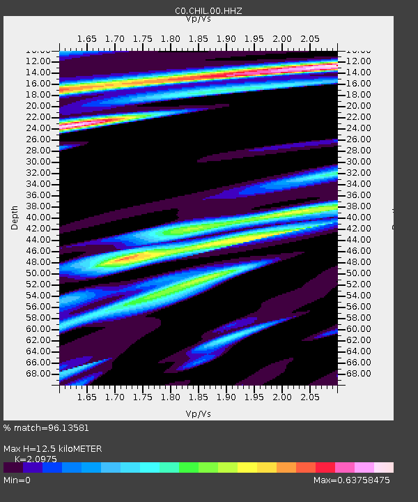
| Estimated Moho Depth: |
12.5 km |
| Estimated Crust Vp/Vs: |
2.10 |
| Assumed Crust Vp: |
6.306 km/s |
| Estimated Crust Vs: |
3.006 km/s |
| Estimated Crust Poisson's Ratio: |
0.35 |
|
| Radial Match: |
96.13581 % |
| Radial Bump: |
400 |
| Transverse Match: |
86.38757 % |
| Transverse Bump: |
400 |
| SOD ConfigId: |
27527651 |
| Insert Time: |
2022-06-09 12:08:35.406 +0000 |
| GWidth: |
2.5 |
| Max Bumps: |
400 |
| Tol: |
0.001 |
|

Signal To Noise
| Channel | StoN | STA | LTA |
| C0:CHIL:00:HHZ:20220526T12:11:56.763977Z | 42.95273 | 2.8843372E-6 | 6.715143E-8 |
| C0:CHIL:00:HHN:20220526T12:11:56.763977Z | 4.4545784 | 5.8739084E-7 | 1.3186228E-7 |
| C0:CHIL:00:HHE:20220526T12:11:56.763977Z | 3.109095 | 3.4216302E-7 | 1.1005229E-7 |
| Arrivals |
| Ps | 2.3 SECOND |
| PpPs | 5.9 SECOND |
| PsPs/PpSs | 8.2 SECOND |


