You are here: Home > Network List > CC - Cascade Chain Volcano Monitoring Stations List
> Station SVIC Surveyor's Cave, OR, USA > Earthquake Result Viewer
SVIC Surveyor's Cave, OR, USA - Earthquake Result Viewer
| Earthquake location: |
Southern Peru |
| Earthquake latitude/longitude: |
-15.0/-70.4 |
| Earthquake time(UTC): |
2022/05/26 (146) 12:02:19 GMT |
| Earthquake Depth: |
212 km |
| Earthquake Magnitude: |
7.2 Mi |
| Earthquake Catalog/Contributor: |
NEIC PDE/at |
|
| Network: |
CC Cascade Chain Volcano Monitoring |
| Station: |
SVIC Surveyor's Cave, OR, USA |
| Lat/Lon: |
43.64 N/121.25 W |
| Elevation: |
1765 m |
|
| Distance: |
74.6 deg |
| Az: |
324.264 deg |
| Baz: |
128.972 deg |
| Ray Param: |
0.051688395 |
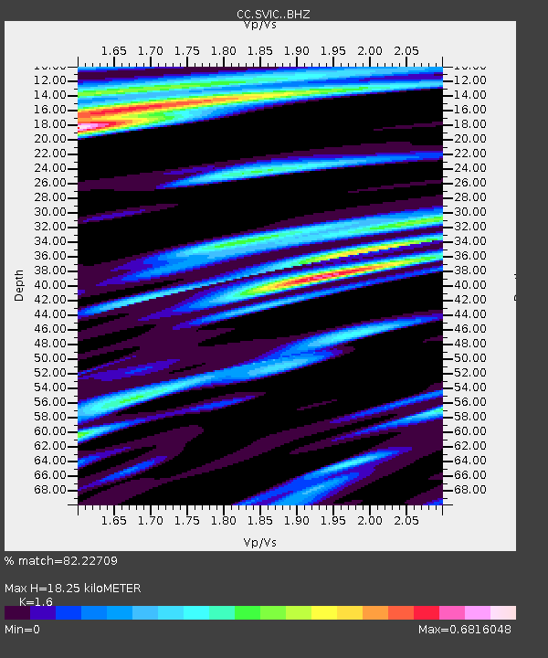
| Estimated Moho Depth: |
18.25 km |
| Estimated Crust Vp/Vs: |
1.60 |
| Assumed Crust Vp: |
6.597 km/s |
| Estimated Crust Vs: |
4.123 km/s |
| Estimated Crust Poisson's Ratio: |
0.18 |
|
| Radial Match: |
82.22709 % |
| Radial Bump: |
400 |
| Transverse Match: |
71.55892 % |
| Transverse Bump: |
400 |
| SOD ConfigId: |
27527651 |
| Insert Time: |
2022-06-09 12:10:25.468 +0000 |
| GWidth: |
2.5 |
| Max Bumps: |
400 |
| Tol: |
0.001 |
|

Signal To Noise
| Channel | StoN | STA | LTA |
| CC:SVIC: :BHZ:20220526T12:13:03.47998Z | 11.394855 | 1.1653196E-6 | 1.0226718E-7 |
| CC:SVIC: :BHN:20220526T12:13:03.47998Z | 1.9336914 | 2.6189187E-7 | 1.3543624E-7 |
| CC:SVIC: :BHE:20220526T12:13:03.47998Z | 1.6840192 | 2.6540803E-7 | 1.5760392E-7 |
| Arrivals |
| Ps | 1.7 SECOND |
| PpPs | 6.9 SECOND |
| PsPs/PpSs | 8.6 SECOND |


